Arctic air creates dangerously cold wind chills in Philadelphia Tuesday. Here's the weather forecast.

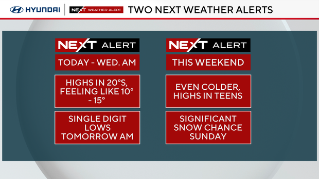
Arctic cold combined with breezy winds will create dangerously cold wind chills Tuesday morning across the entire Philadelphia region.
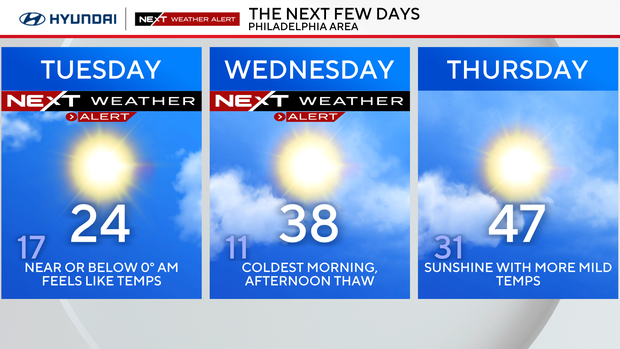
A NEXT Weather Alert has been issued for these conditions as we wake up with feels-like temperatures ranging from around 5 degrees to 15 degrees below zero. The coldest conditions will be felt across the Lehigh Valley and the Poconos, but the entire region will feel the bitter chill of this Arctic blast.
Despite mostly sunny skies, temperatures in the afternoon will only warm into the low-middle 20s, with feels-like temperatures remaining in the single digits and teens all day. You'll want all the layers and plenty of time indoors today until tomorrow morning.
Even colder temperatures will settle in Tuesday night into Wednesday morning with lows expected near 10 degrees in Philadelphia. The winds, however, Wednesday will be weaker, which will keep the feels-like temperatures mainly above zero.
NEXT big weather change
After a brief warm-up through the second half of the week, another Arctic blast will arrive going into the weekend.
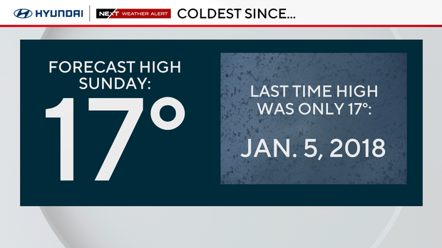
High temperatures both Saturday and Sunday look to only peak around 20 degrees, with low temperatures back into the single digits to around 10 degrees.
What's the deal with weekend snow?
You may have seen images floating around the internet showing snow measured in feet coming to the northeast. While those images are outlandish and not expected, there is an increasing potential for a significant winter storm this weekend.
The potential for 6 or more inches is looking likely. There is an increasing threat of a major snowstorm, mainly on Sunday, across the Philadelphia region. At last check, most models waver somewhere between 6 and 15 inches of snow.
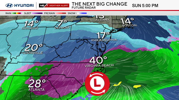
However, it's important to recognize that we are still five days out from the onset of precipitation, the disturbance hasn't yet formed, and the track will likely shift, and our forecast will change accordingly.
Here's what we know:
- A fresh infusion of arctic cold will arrive Saturday, with highs only in the teens and overnight lows in the single digits
- An area of low pressure will develop near the Gulf of Mexico, move through the Deep South and exit off the east coast Sunday, potentially into Monday
- Any precipitation that falls in the Philadelphia area will fall as snow with temperatures no better than the teens
- Snow that falls when the air is that cold is what we call "high ratio snow," which basically means a lighter and fluffier snow that doesn't compact as it falls, and that generally brings higher totals, unlike the snow from this past weekend
Stay with your NEXT Weather team for all the latest. We'll analyze the trends and call on our many years of combined experience forecasting these types of storms to bring you the most pertinent and updated information as we get it.
Here's your 7-day forecast:
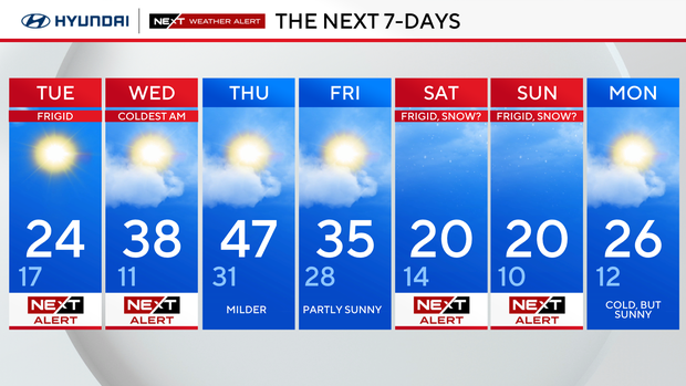
Tuesday: NEXT Weather Alert for frigid temps. High 24, Low 17
Wednesday: NEXT Weather Alert for coldest morning. High 38, Low 11
Thursday: Milder. High 47, Low 31
Friday: Partly sunny. High 35, Low 28
Saturday: NEXT Weather Alert for Frigid, snow? High 20, Low 14
Sunday: NEXT Weather Alert for Frigid, snow? High 20, Low 10
Monday: Cold but sunny. High 26, Low 12