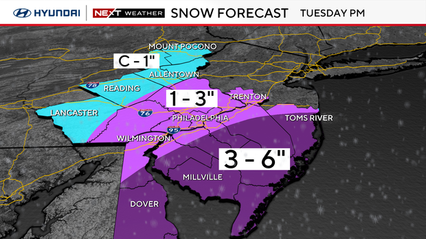
Philadelphia could get 1-3 inches of snow Tuesday, higher totals expected across South Jersey
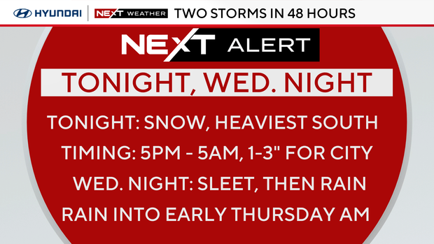
Get ready for two storms in 48 hours, followed by a third this weekend. A NEXT Weather Alert is in effect today, Wednesday and Thursday due to the chance for accumulating snow, a wintry mix and icy, slippery roads.
School closings, delays in Philadelphia area on Feb. 12
Several schools have already announced delays and schedule changes for Wednesday. The School District of Philadelphia will operate on a two-hour delay. See the full list.
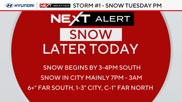
How much snow will Philadelphia get?
The heaviest totals will be south and east over the Jersey Shore, far South Jersey, and the southern half of Delaware. This is where 6 inches could fall. On either side of the I-95 corridor, including Philadelphia, there will be accumulating snow. Right now, Philly looks like it'll be in the 1-3 inches range.
For the Lehigh Valley and Poconos, there will be very little snow, possibly none at all.
What time will it snow in Philadelphia?
Snow will begin falling late in the afternoon and early evening. It will continue overnight and end by 6 a.m. Wednesday.
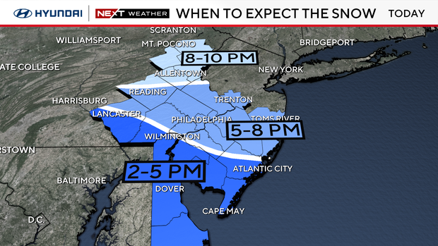
The current storm track is moving south of the Delaware Valley, placing us in all snow, but a trend further south means we may miss out on higher accumulations.
If this track remains consistent, there will be a sharp cutoff in the snow as we head northwest from the shore to the Poconos.
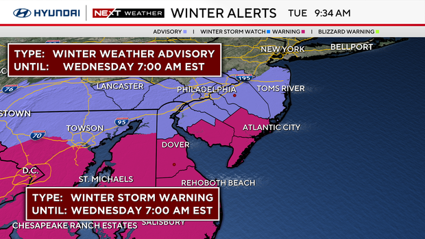
The National Weather Service has issued a winter storm warning from 1 p.m. Tuesday until 7 a.m. Wednesday in areas where heavy snow is expected, including the following counties: Atlantic, Cape May and Cumberland.
A winter weather advisory is also in effect from 4 p.m. Tuesday until 7 a.m. Wednesday in Philadelphia. The city's Office of Emergency Management said the winter weather advisory is in effect for Delaware, eastern Montgomery, Philadelphia and Chester counties.
Wintry mix continues Wednesday
Most of Wednesday is dry, just cloudy and cold, but a wintry mix arrives later at night. The storm will quickly change to rain in the city, with little to no snow accumulation.
Farther north, sleet or a wintry mix is possible for a longer period, which could make the roads slippery.
Icy, slippery conditions Thursday
Showers will linger during the Thursday morning commute, and icy and slippery roads are possible, especially outside of Philadelphia.
Rain is forecast to end early enough that conditions will dry out in the afternoon, and we could even see a few breaks of sun.
Code Blue in effect in Philadelphia
Philadelphia will have a Code Blue in effect from 3 p.m. Tuesday through 9 a.m. Thursday because of this winter weather. Intake centers will be available to anyone in need, the city said on social media.
You can find a shelter on the city's website or call the homeless outreach hotline at 215-232-1984. You can also call the number if you see someone who needs help.
Weekend outlook
We're also tracking the chance for even more wintry weather on Saturday and Sunday. Another storm could arrive Saturday evening, packed with mostly rain and maybe a brief mix of snow at the end. The system moves out Sunday but will be followed by a blast of wind and cold air for President's Day on Monday.
Here's the 7-day forecast:
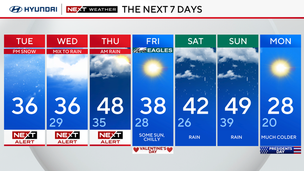
Tuesday: NEXT Weather Alert for evening snow. High 36.
Wednesday: NEXT Weather Alert for winter storm mix and rain. High 36, low 29.
Thursday: NEXT Weather Alert for morning rain. High 48, low 35.
Friday: Some sun, chilly. High 38, low 28.
Saturday: Rain. High 42, low 26.
Sunday: Rain likely. High 49, low 39.
Monday: Much colder. High 28, low 20.
Get the latest weather info on the CBS News Philadelphia app.


