Philadelphia weather: Cloudy Super Bowl Sunday, tracking rain and slushy snow for Tuesday


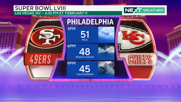
PHILADELPHIA (CBS) -- Mild, cloudy weather continues for Super Bowl Sunday. And while last week gave us a taste of spring, more wintry weather is on the way this week.
The high temperature today in Philadelphia and across the Jersey Shore Sunday will be close to 52 degrees. Up in the Lehigh Valley, we're looking at a high of 49.
Monday is mostly cloudy again with mild temps close to 50 and rain developing in the afternoon.
Winter storm moves in Monday and Tuesday
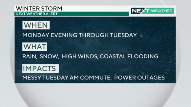
Tuesday is a NEXT Weather Alert Day as rain and snow are likely to impact the morning commute.
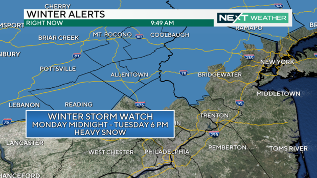
A Winter Storm Watch is set to go into effect for the Lehigh Valley, Poconos, northern Bucks and Berks Counties Monday night until 6 p.m. Tuesday. A Coastal Flood Watch will be in effect Tuesday for Atlantic and Burlington Counties, where 1-2 inches of moderate flooding is possible.
After 2 a.m. Tuesday, rain will chance over to wet snow for areas adjacent to I-78 including the Poconos, Lehigh Valley, and parts of upper Bucks and Montgomery Counties. A transition line of rain/snow mixing looks to swing through Philadelphia between 6-9 a.m., bringing a quick burst of wet, sloppy snow.
The warm ground will help melt much of what falls in and around the city, but generally a trace to an inch or two of slush is possible in Philadelphia, with the higher totals farther north.
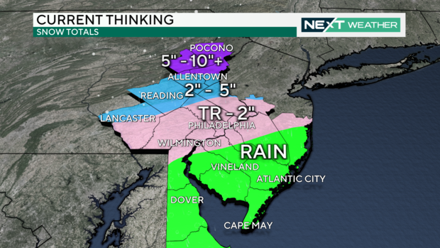
While there is still time for the storm track to change, as of Sunday we're looking at between 2-5 inches from Reading to Allentown, with totals up to 10 inches possible in the Poconos. These amounts could go up or down before Tuesday, so keep an eye on CBS Philadelphia for the latest weather updates.
Inland South Jersey, the Shore and southern Delaware should expect to see mostly rain.
Winds pick up Tuesday with 30-40 gusts in the late morning through the afternoon, but the temperature Tuesday will climb to 40 degrees. Expect slushy roads Tuesday morning, and the chance for school delays or remote learning father northwest.
Timing
Monday
- 6-10 p.m.: Rain arrives in the Delaware Valley
Tuesday
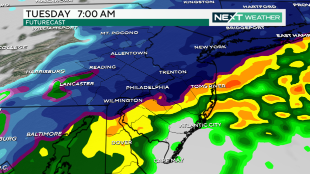
- Midnight to 4 a.m. Tuesday: Rain changes to snow in the Poconos, Lehigh Valley, Upper Bucks and Montgomery County (areas near I-78)
- 7-9 a.m.: Rain mixes with snow for areas in PA closest to I-95, including Philadelphia
- 9-11 a.m.: Slushy snow falls for all areas except inland South Jersey, the Shore, and much of Delaware, where rain will fall
- 11 a.m.-2 p.m.: Storm exits the area
- Afternoon: Temperatures climb to upper 30s and low 40s for Philadelphia and surrounding areas and the snow melts
7-day forecast:
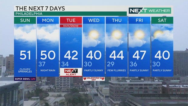
Sunday: High of 51, cloudy with a chance for some sprinkles
Monday: High of 50, low of 37, night rain
Tuesday: High of 42, low of 34, NEXT Weather Alert Day
Wednesday: High of 40, low of 30, partly sunny
Thursday: High of 44, low of 29, few flurries
Friday: High of 47, low of 36, partly sunny
Saturday: High of 40, low of 30, partly sunny