NEXT Weather Alert for winter weather Saturday in the Philadelphia region. Here's the forecast.

Saturday is a NEXT Weather Alert day for wintry weather. A winter weather advisory has been issued for a majority of the region, with Cape May County, the immediate Jersey Shore and southern Delaware the exception.
While most of the region doesn't get major snow from this storm, there's a threat of icy roads that you should be aware of. Beyond that, we are tracking THREE other upcoming winter storms between now and next Saturday, Feb. 15.
For this first storm on Super Bowl Eve, key times to be weather aware are between 6 p.m. Saturday and 6 a.m. Sunday. We are tracking a wintry mix that could include snow, sleet, freezing rain and plain old rain, with temperatures overnight getting below freezing — with the potential to create a big icy mess on the roads.
If you happen to be driving tonight or in the early hours of Sunday morning: use caution.
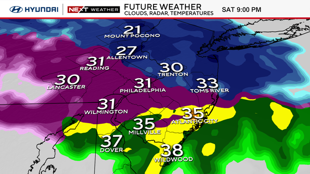
One silver lining is that temperatures on Sunday will get above freezing. The ice threat will subside as temperatures rise to a high of 42 in the city and high 30s outside.
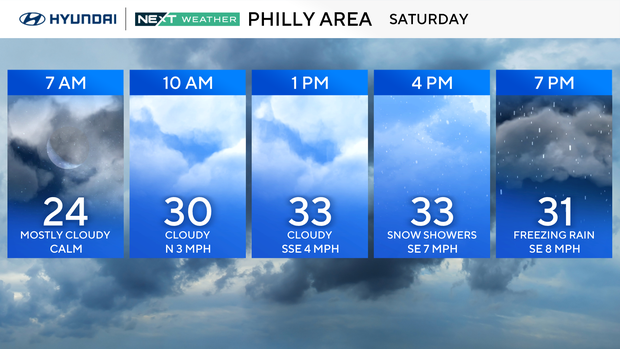
When will it snow and when will it rain in the Philadelphia area?
From 7 p.m. to 10 p.m., freezing rain and sleet along the I-95 corridor including Philadelphia, lower Bucks, Montgomery, Chester, and New Castle counties along with interior South Jersey.
Farther north and west the snow will continue for the Lehigh Valley, Berks County, upper Bucks County, upper Montgomery County, and the Poconos.
While the Poconos and Lehigh Valley could see 2-5 inches of snow, the remainder of our area will see less than an inch of snow.
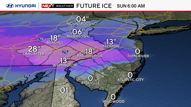
The immediate shore will see mainly rain. From around 10 p.m. to 11 p.m., freezing rain continues over I-95 and southeast Pennsylvania including Philly. Up to two-tenths of an inch of ice will coat any untreated surfaces or streets.
From 11 p.m. to 3 a.m., all areas change to rain except the Poconos, Lehigh Valley, Berks, upper Bucks and upper Montgomery counties where snow changes to patchy freezing rain.
From 3 a.m. to 5 a.m., all precipitation is finished.
On Sunday that weather system moves out and we have a dry day to watch the Birds win the Super Bowl. Temps on Sunday and Monday will be chilly but enough to melt any ice, with highs in the upper 30s and low 40s.
Monday will also be dry with partly sunny skies. It is the calm before winter storm No. 2.
Tuesday evening and Wednesday, another winter storm will cross the region — and accumulating snow is likely. There will be a sharp cutoff in the snow, with the lowest totals north and west of Philly and the highest totals south and east of Philly.
On Thursday, storm No. 3 arrives, with a wintry mix changing to rain.
Friday looks partly cloudy and dry at this point.
Saturday and Sunday, storm No. 4 arrives with a wintry mix and rain.
Here's the 7-day forecast:
Saturday: NEXT Weather Alert for afternoon snowy mix. High 34, low 24.
Sunday: Nice for Birds. High 43, low 30.
Monday: Partly sunny. High 40, low 28.
Tuesday: NEXT Weather Alert afternoon snow. High 34, low 24.
Wednesday: NEXT Weather Alert for snow. High 33, low 29.
Thursday: NEXT Weather Alert for snow/rain. High 47, low 31.
Friday: Sun returns. High 37, low 24.
Get the latest weather info on the CBS News Philadelphia app.