How a "super" El Niño could impact winter and snow in the New York area
Although fall has recently just begun, much attention is already being turned to the upcoming winter.
There's a good reason for this, too. Not only is this impending winter anticipated to feature El Niño, but what's being dubbed a "Super" El Niño at that.
What is El Niño?
El Niño is a natural phenomenon, characterized by the warming of sea surface temperatures in the central and eastern tropical Pacific Ocean. It's triggered by a weakening of trade winds that normally blow from east to west and push warm water towards Asia and Australia. This weakening of the trade winds then allows the warm water to flow towards the west coast of South America instead. It occurs every two to five years, and sometimes a single event can last up to three years. Despite occurring in the Pacific Ocean, it can have far-reaching global effects that alter weather patterns worldwide. Such effects include drought in Indonesia and Australia, increased precipitation in California, as well as in the southern and eastern United States, and suppressed hurricane activity in the Atlantic Ocean. Additionally, the large pool of warmer than average water in the tropical Pacific Ocean can lead to a spike in global temperatures by releasing extra heat into the atmosphere.
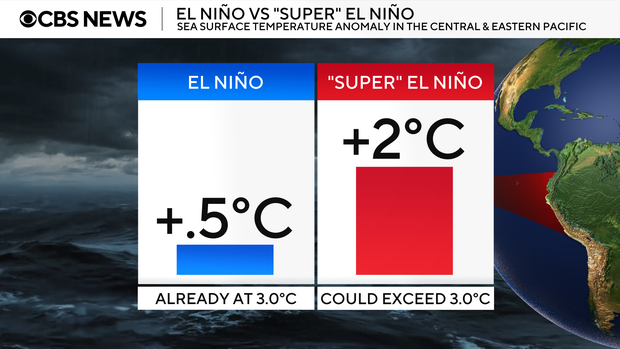
To be classified as an El Niño event, sea surface temperatures in the central-east Pacific Ocean, also known as the Niño 3.4 Region, must reach 0.5 degrees Celsius above normal. Once temperatures reach 2 degrees Celsius or higher above normal, a very strong or "Super" El Niño event is declared. Currently, water temperatures in the Niño 3.4 Region have already reached 3 degrees Celsius above average, indicating that a "Super" El Niño is already underway. Even further warming is expected, as El Niño typically peaks between November and January. By then, it's highly likely that water temperatures will exceed 3 degrees Celsius above normal. That warming trend could make this current El Niño the strongest ever recorded.
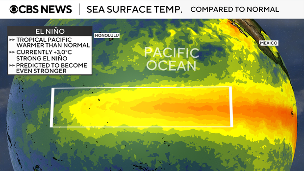
The effects of the "Super" El Niño are already playing out. One glaring example is the current hurricane season in the Atlantic Basin. To date, only seven storms have been named. None has reached hurricane status, and of the storms that have formed, most have been weak and very short lived. The lack of tropical cyclone activity in the Atlantic is due to an increase in upper-level winds of the atmosphere, known as shear, a direct result of weakened surface trade winds over the equatorial Pacific. Since hurricanes are vertically stacked systems, the heightened shear over the Atlantic essentially cuts the top off any would-be storm, thus curtailing its development. At this rate, it's quite possible that 2026 may finish as one of the least active hurricane seasons in the Atlantic, following years of hyper-active storm activity.
Consequently, many of the Caribbean Islands, such as Puerto Rico, are in a severe drought. Even though they can be destructive, these islands rely on rainfall from tropical systems to maintain their water supply. Meanwhile, tropical cyclone activity in the eastern Pacific Basin is running well above average, with 20 named storms so far.
El Niño in the Tri-State Area
Typically, El Niño delivers above average temperatures and above average precipitation to the Tri-State Region. The above average precipitation trend has already begun, as evidenced by this past summer's extreme wetness. However, the effects of El Niño in our region tend to peak during the winter months. During winters that feature El Niño, the chance of coastal storms developing increases dramatically, with an active jetstream pattern. These can be in the form of nor'easters that produce mainly rain, mainly snow, or a mix of both.
Timing is everything
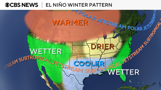
As the polar jetstream is pushed further north by the warmer than average water in the Pacific Ocean, El Niño winters in the northern United States, including the New York Metropolitan area, usually have milder than normal temperatures. At the same time, the sub-tropical jetstream is also pushed northward, thus funneling more moisture from the Pacific into the southern and eastern tiers of the nation, leading to above average precipitation.
Even though overall winter temperatures trend higher than normal during El Niño, that doesn't mean cold air can't be in place. When that cold air from the north mixes in with the steady stream of moisture from the south, interesting weather can unfold.
El Niño and snowfall
In other words, this would be a scenario when the northern branch of the jet stream and southern branch of the jet stream combine, a term meteorologists call "phasing". When phasing occurs over our region, it can lead to blockbuster snowstorms. Phasing over our area happens to be very common during El Niño winters. For example, the infamous El Niño winter of 2009-2010, which was of moderate strength, produced 51.4 inches of snow in Central Park. Of those, 36.9 inches fell in February 2010, and that month holds the record for snowiest month ever recorded. In an average winter, 29.8 inches typically fall.
Climatologically speaking, central and southern New Jersey are the favored locations for above-average snowfall during El Niño winters across the Tri-State Region.
Past El Niños
The "Super" El Niño that is currently upon us is rare and could be one of the strongest ever recorded. Since the late 1990s, only two other "Super" El Niños have developed. The first was between 1997-1998. During that winter, very mild temperatures, the sixth warmest on record in NYC, led to lots of rainfall, but only 5.5 inches of snow, the seventh least snowy on record. On the contrary, the last "Super" El Niño that occurred between 2015-2016 produced 32.8 inches of snow in the park. Most of that snowfall came from one major storm in January 2016, where phasing did occur. That storm dumped 27.5 inches of snow, becoming the biggest snowstorm in New York City history. Aside from that storm, cold air was mainly absent, and the winter finished in second place for the warmest winter ever.
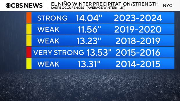
Our most recent El Niño transpired between 2023 and 2024 and was of strong strength. In typical El Niño fashion, the corresponding winter was very mild, the third warmest ever recorded, while only 7.5 inches of snow fell, placing it in ninth place for least snowy season ever. In stark contrast to that winter, the El Niño winter of 2014-2015, which was of weak strength, was one of the coldest ever recorded in NYC, and one of the snowiest, producing 50.3 inches of snow.
What will this winter bring to the Tri-State?
In summary, El Niño winters in New York can have many different outcomes. Past El Niño data strongly suggests that overall, winters during the phenomenon are warmer and wetter than normal in the Tri-State Region, especially those of "Super" strength, and those of moderate strength have the highest likelihood of producing above average snowfall.
Given that this current El Niño is so strong, there is a high probability that it will be warmer than average, with lots of rain and not much snow. Nonetheless, the overall pattern of the last two winters was colder than normal. The odds favor the cold trend reversing, but it's also possible that the cold trend persists. Regardless of warmer than normal temperatures, only a marginal amount of cold air is needed to produce snowstorms. So, if the excess available moisture associated with El Niño combines with cold air at the right time, we are in for another snowy winter that could rival last year.
Besides affecting winter temperatures and precipitation locally, shoppers may experience higher prices at the grocery store for produce in the winter and spring. Just as we see more storm activity, so too does California during El Niño. Many times, that leads to flooded fields and damaged crops in the Golden State, where a large portion of the nation's fruits and vegetables are grown during the colder months.


