NEXT Weather: Brief return of dangerous cold, before long streak of above-average warmth
MINNEAPOLIS – If Punxsutawney Phil lived in Minnesota, he would certainly take this Groundhog Day off.
Temperatures in the Twin Cities will start out kind of mild Thursday morning – around 11 degrees for the day's high – before taking a big tumble.
North-by-northwestern winds with speeds between 15-20 mph will start dragging in dangerously cold air by the afternoon. There might be a few isolated flurries Thursday morning, coinciding with this frontal passage.
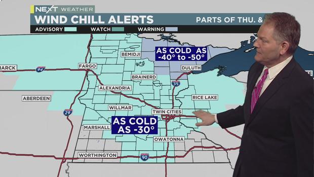
The National Weather Service has issued a widespread Wind Chill Advisory through Friday -- a NEXT Weather Alert day -- due to temps that could feel as cold as -30. The biggest concern is in the northeastern corner of Minnesota, where it could feel like -40 and colder. The region is under a Wind Chill Warning, with air temps that could cause frostbite on exposed skin in less than 10 minutes.
The winds will settle down by Friday morning and we'll begin to stabilize a bit, but there won't be much of a recovery, with the day's high at just 7 degrees in the metro.
But hang in there, because we'll see a big temperature jump this weekend. Saturday's high will be 31, and Sunday's will be 32. Both days will be breezy, with Saturday holding a chance of snow along the I-90 corridor.
Monday will be even warmer, and will feature our next best chance of precipitation. It looks like it will be light, and feature some drizzle mixed in with snowflakes.
And more good news for mild-temp lovers: Models are showing that above-average warmth will linger well beyond the first week of February.