Slight warmup Thursday in Twin Cities after subzero morning; more snow ahead


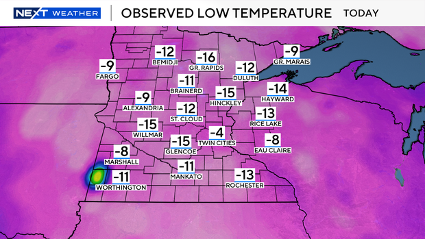
After the coldest morning Twin Cities residents have felt since mid-February, temperatures gradually warm through Thursday afternoon and evening.
A southerly breeze — with gusts near 30 mph Thursday night — will keep wind chills below zero all day, but get air temps to the teens by the evening hours.
Some models are showing another clipper into Saturday night, but there's uncertainty with the track. Regardless, amounts will be light and mainly confined from the metro southward.
Another arctic high slides in Saturday, dropping temps again for the weekend:
* Saturday morning: temps in the low-teens, with feels-like temps in the single digits.
* Saturday Afternoon: highs near 20 degrees, but feels like the single digits.
* Sunday morning: temps near zero, but feels like minus 10.
* Saturday afternoon: temps near 10, but feels like zero.
This pattern will remain active into next week, with the potential for a stronger system Tuesday into Wednesday.
Temps will rebound back into the 20s late Monday through Wednesday as well.