Minnesota Weather: South Metro Gets 12+ Inches Of Snow; More Expected Overnight
RESOURCES: School Closings | Live Radar | Weather App
Read the latest weather update with snowfall totals here.
MINNEAPOLIS (WCCO) -- The first significant winter storm of the season for southern Minnesota roared into the state on Friday, with the heaviest snow band cutting across the heart of the Twin Cities. Hours before the flakes were expected to stop falling, several south metro communities already saw over a foot of snow. Meanwhile, both Minneapolis and St. Paul declared their first snow emergencies of the season.
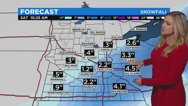
After sundown, the system's heaviest snow band set up across southern Minnesota, stretching from New Ulm in south-central Minnesota and slashing through the southern half of the metro area. Meteorologist Lisa Meadows says snowfall rates were at 1 to 2 inches per hour through the evening, leaving communities under the narrow snow band -- such as Eagan, Apple Valley and Woodbury -- with well over a foot of snow. Outside of this narrow band, snowfall rates were significantly lower.
It's unclear how much more snow could stack up in the Twin Cities before the system pushes into western Wisconsin early Saturday morning. According to Meadows, the heavy snow band appeared to be breaking up in the late evening and pivoting to the southeast. However, the system still looks to drop about 2 more inches of snow in the Twin Cities before moving into western Wisconsin. Communities across the Mississippi, such as Eau Claire, Wisconsin, should expect about 4 more inches of snow before sunrise.
Earlier in the day, the snowstorm caused significant travel headaches. More than 250 flights were canceled at Minneapolis-St. Paul International Airport, and hundreds of crashes were reported on slippery roads across southern Minnesota, including a seven-car pile-up on Interstate 35 near Faribault.
According to the Minnesota State Patrol, there were 232 crashes, 134 spin-outs and 14 jackknifed statewide between 6 a.m. and 9 p.m. In those incidents, 19 people were hurt, but none fatally. After nightfall, Metro Transit said that about half of its buses were running behind schedule in the Twin Cities, with an average delay of nearly 10 minutes.
Ahead of the storm, several school districts across southern Minnesota canceled classes or let students out early. Many businesses across the metro also decided to close early for the night.
With more than a foot of snow on the ground in some areas, does this storm mean southern Minnesota is in for a white Christmas? No. A stretch of unseasonably warm weather will kick off this weekend, and by next week the metro area could see rain and temperatures near 50 degrees. In other words: There'll be lots of melting in the days to come.
WHAT WE KNOW
-
- A winter storm warning covers southern Minnesota and the Twin Cities
- Both Minneapolis and St. Paul have declared snow emergencies
- Biggest snow totals seen across the south metro
- Snow stops by sunrise Saturday
- Warmer temperatures and melting are in the forecast
WHAT WE'RE TRACKING
-
- Exactly how much snow will stack up across Minnesota
- Whether temperatures will climb near 50 degrees next week
The National Weather Service has issued a winter storm warning for southern Minnesota and most of the Twin Cities until 6 a.m. Saturday. Meanwhile, the northern border of the metro and much of central Minnesota are under a winter weather advisory.
According to Meadows, a band of moderate snow first arrived in the Minneapolis-St. Paul area around 1 p.m. After a few hours of snowfall, there was a slight clearing before another snow band pushed up from the south. This band brought heavy snow to the south metro, from Chaska to Woodbury, where snow quickly stacked up in the early evening.
The snow is expected to continue falling fast in the south metro through the late evening before tapering off as the system pushes into western Wisconsin in the overnight hours. During this time, travel in the metro and across southern Minnesota will be difficult. According to MnDOT, roads across the southern half of the state are completely covered with snow.
Parking & Plowing
If you park on the street, be careful. Minneapolis declared a snow emergency Friday afternoon. Starting at 9 p.m., Day 1 rules began, meaning that motorists should not park on snow emergency routes or risk getting towed. On Saturday morning, plows will begin clearing the even sides of residential streets.
St. Paul also declared a snow emergency. Starting at 9 p.m., crews began plowing Night Plow Routes. After 8 a.m. Saturday, crews will start plowing Day Routes.
As for the suburbs, snow emergencies have been declared in Crystal, St. Louis Park, New Hope, Eden Prairie, Richfield, and Brooklyn Park, among other cities. (For more information on snow emergency rules in Minnesota, click here.)
And don't forget to shovel sidewalks. Homeowners have 24 hours to clear a path in Minneapolis or face a possible ticket. All other properties, like businesses and apartment complexes, have to clear sidewalks within four hours of sunrise.
After The Storm, A Warm-Up
Saturday looks to be clear, with sunny skies and temperatures in the low 30s. This should help as crews work to clear the roads of snow and ice. Additionally, a warming trend will kick-off Sunday, when temperatures are expected to climb above freezing.
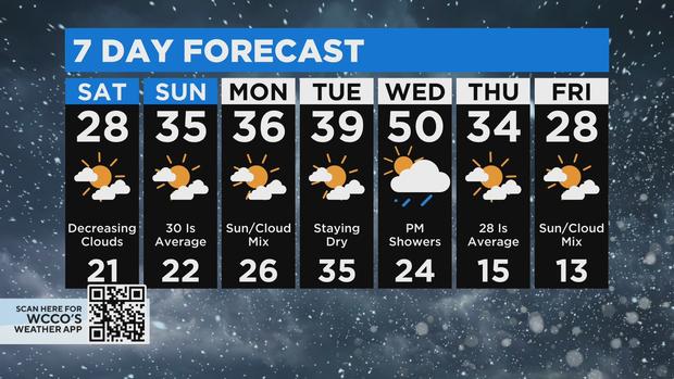
The warmer weather looks to extend through much of next week, peaking Wednesday when the mercury could climb near 50 degrees in the Twin Cities. No matter how much snow Friday's ends up dumping on the Twin Cities, much of it will melt in the following days, and whatever's left could be washed away by a chance of mid-week rain.
For context, the average high temperature for mid-December in the Twin Cities is in the mid-20s. The average low is about 12 degrees.


