Maps show where in Minnesota more than a foot of snow could fall this weekend


A major winter storm is bringing significant snow and wind to parts of Minnesota and Wisconsin this weekend.
According to WCCO's Next Weather Watchers, 15 inches of snow fell overnight in Wabasha, with areas like Lakeville and Cannon Falls seeing more than 12 inches.
Closer to the Twin Cities, Savage got around 10.5 inches of snow. Champlin saw 6.4 inches, and Edina saw 5.7 inches.
The Twin Cities could see another six inches, with areas like Red Wing expecting around 6 to 10 inches. Snow won't be as much of an issue to the north or to the west.
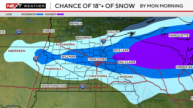
Northern Minnesota likely won't see much snow, if any at all.
Other historic Minnesota snowstorms
Minnesota, of course, is no stranger to big winter storms. The biggest Twin Cities snowstorm on record is the Halloween blizzard of 1991, when nearly 28.5 inches fell through Nov. 3.
The biggest March snowstorm was in 1985 when the metro picked up almost 17 inches between March 3 and March 4.
The most recent major storm was in 2023, which featured the winter when the metro saw 90 inches of snow.
One of the biggest storms that season came in early January when the metro saw a little over 15 inches of snow between Jan. 2 and Jan. 5.
Meteorologically speaking, it's no surprise some of our biggest snowstorms have happened in March. Seven of our top 25 snowfalls have occurred in this month.
And like in the beginning of the season, storms have more access to moisture to translate to heavy snow.
Rounding out the top five for March is 1952 with 14.1 inches. And given our current forecast, it's certainly possible this weekend's storm makes it on this list.


