Spotty afternoon storms across South Florida, higher rain chances mid-week

Monday got off to a dry and warm start with temperatures mostly in the upper 70s across South Florida. In the afternoon, highs will climb to the low 90s, and it will feel like the 100s when the humidity is factored in.
Spotty storms will develop in the afternoon and evening, but the rain will not be widespread. A few downpours will be possible.
There is a moderate risk of rip currents along the Atlantic beaches, and the UV index is very high. There are no alerts or advisories for boaters over the Atlantic or Florida Keys waters.
The chance of rain is higher for Tuesday as more widespread storms are expected as a frontal boundary begins to lift northward. Highs will continue in the low 90s.
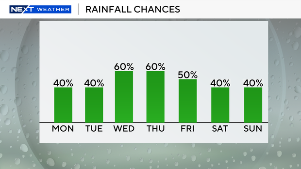
Wednesday and Thursday have a higher chance of rain due to plenty of moisture around, which will lead to more widespread showers and storms. There is the potential for some heavy rain and localized flooding. With more wet weather around, it will not be as hot. Highs will be in the upper 80s mid to late week.
Friday remains unsettled with scattered storms. Over the weekend, the chance of rain decreases slightly, with passing storms possible on Saturday and Sunday.
The NEXT Weather team is tracking a tropical wave over the central Atlantic with a high potential of development (80% chance) as it moves to the west-northwest at 10 to 15 miles per hour. This system is forecast to move into a more favorable environment for development, and it may become a tropical depression or tropical storm mid to late week.


