Bundle up, South Florida! Winter Returns To The Sunshine State
Follow CBSMIAMI.COM: Facebook | Twitter
MIAMI (CBSMiami) -- Sweater weather is back courtesy of a cold front that swept through South Florida Wednesday night and Thursday morning.
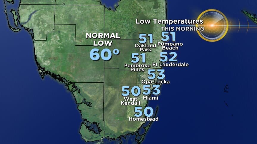
North-Northwesterly winds are ushering cooler and drier air. It is a chilly start with most of Broward and Miami-Dade waking up with low 50s. Some inland areas dipped down to the upper 40s.
Average low this time of year: 60 degrees.
Folks across the Keys are even enjoying cooler temperatures in the low 60s and upper 50s.
Throughout the day Thursday, we'll remain cool despite plenty of Winter sunshine.
Highs will only climb to the upper 60s and with a brisk breeze in place, it will feel quite cool to the skin. Average high this time of year: 76 degrees.
The only concern Thursday is that there is an elevated fire risk due to dry conditions in place. Relative Humidity levels could fall below 25% and winds will range from 10 to 15 miles per hour. The most significant fire danger will be across the Interior and Western sections. South Florida is currently in a moderate drought we haven't seen any significant rain in quite some time.
Thursday night with a clear sky and calm wind expect another cold night especially over the interior.
Typically following a cold front when the wind diminishes you get a significant temperature range between the coast and inland areas.
Thursday night will be no different with areas away from the coast falling into the lower 50s and even the upper 40s while near the coast it will be about 5 to 10 degrees warmer.
The gradual warming trend begins Friday afternoon. High pressure moves into the Atlantic and winds will start to shift in off the Ocean.
More of an onshore flow will lead to milder temperatures Friday afternoon as highs climb to the low to mid 70s. A few showers will be possible Friday.
Friday night into Saturday morning will not be as cold. Lows will be in the low to mid 60s.
By Saturday afternoon highs will be near normal with the upper 70s and the potential for spotty showers on the breeze.
Sunday will be even warmer and humid with highs in the low 80s and some passing showers will be possible.
Our next cold front arrives on Monday. Slightly cooler air will move in and we'll enjoy pleasant and seasonable highs in the upper 70s by Monday afternoon.


