Miami could see near record heat, cool down coming this weekend

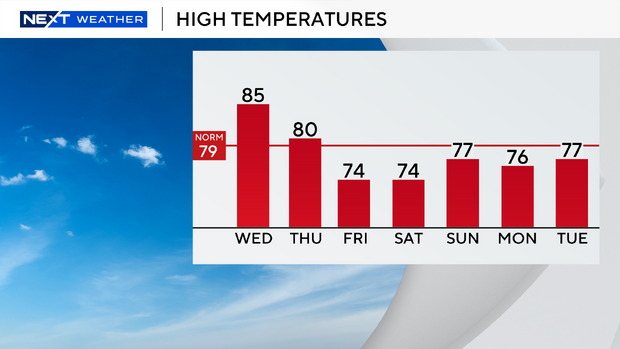
MIAMI - We're in for the hottest day of the week on Wednesday as highs will soar to the mid to upper 80s.
Near record heat will be possible.
The NEXT Weather team is forecasting a high of 85 degrees in Miami, the current record is 87 set back in 1982. The forecast high for Ft. Lauderdale is 84. The current record is 88 degrees set back in 2017, so it is unlikely Ft. Lauderdale will be near or tie records. The forecast high for Key West is 82 degrees, the current record is 85 degrees set back in 2020.
The chance of rain is low but a few isolated showers will be possible. There is a moderate risk of rip currents along the Atlantic beaches. There are no alerts or advisories for boaters along the Atlantic or Keys waters.
Thursday morning will be mild again with temperatures mostly in the low 70s. Highs will climb to the upper 70s due to more clouds around. The chance of rain stays low.
The return of sweater weather
A strong cold front will move in late Thursday night.
Sweater weather returns Friday morning as temperatures tumble to the mid to upper 50s. Our normal low this time of year is 64 degrees in Miami. It will be breezy and pleasant during the day with highs only in the low to mid 70s.
We'll enjoy a cool start on Saturday with temperatures in the low 60s. Highs will climb to the mid 70s under mostly sunny skies. Sunday morning will be comfortably cool with temperatures in the upper 60s, highs will rise to the upper 70s in the afternoon. The rain chance will be higher on Sunday with the potential for scattered showers.