Afternoon storms across South Florida, some may have heavy downpours

A wet Wednesday is ahead as storms will develop in the afternoon and evening with the potential for heavy downpours and localized flooding. The Weather Prediction Center has placed Broward and Miami-Dade under a marginal (Level 1) for flash flooding.
Highs will climb to the low 90s in the afternoon, and it will feel like the low 100s, before the rain rolls in to bring some relief.
There is a low risk of rip currents today along the Atlantic beaches and there are no alerts or advisories for boaters along the Atlantic or Florida Keys waters.
A stalled frontal boundary and a low-pressure system to the northeast will lead to a very moist, unstable atmosphere across South Florida and keep the chance of rain high through late week.
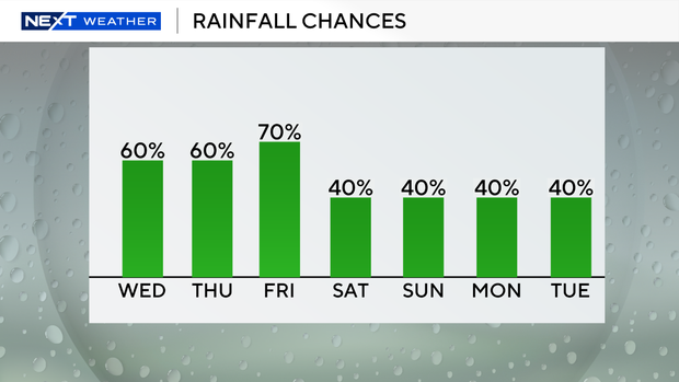
On Thursday morning, expect a few showers, with more widespread storms developing in the afternoon and evening again. Highs will decrease slightly to around 90 degrees due to the wet weather and cloud coverage.
On Friday, South Florida remains unsettled with scattered to numerous storms possible.
This weekend the chance of rain decreases along with our temperatures. Highs will be seasonably hot, near 90 degrees, and spotty storms will be possible on Saturday, Sunday and through early next week.


