Storm passes through Southland bringing less rain than expected
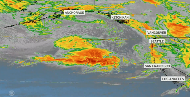
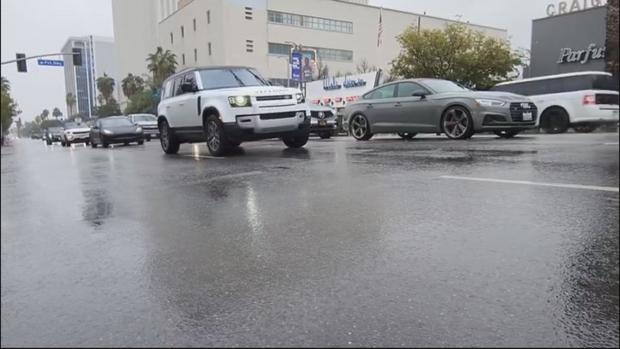
A strong Pacific storm doused Southern California with rain today, flooding some roadways across the Southland and forcing some
freeway lane closures, but the system dropped far less rain than originally expected as it quickly moved through the area.
The main front of the "bomb cyclone" moved into the area overnight, but forecasters said the storm traveled much faster than anticipated, which "greatly reduced the amount of rainfall through the area," according to the National Weather Service.
"This may be one of the most challenging and impactful series of storms to touch down in California in the last five years," said California Office of Emergency Services Director Nancy Ward on Wednesday, before the storm reached the coast. "If the storm materializes as we anticipate, we could see widespread flooding, mudslides and power outages in many communities."
Those living close to burn scars were quick to jump into action, lining streets with sandbags and K-Rails, looking to protect their homes in the event of any flooding, similar to what San Bernardino residents saw in September last year.
Some showers continued to pop up through the day, but fears of isolated thunderstorms failed to materialize.
While the overnight rain was lighter than anticipated, it still managed to cause some flooding and make for a hazardous morning commute.
Flooding in the Sepulveda Basin forced the closure of multiple roads in that area early Thursday morning, helping to snarl traffic in the San Fernando Valley. A stretch of the northbound 710 Freeway was temporarily closed at Artesia Boulevard due to flooding, with some reports indicating 3 to 4 feet of water had accumulated on the roadway.
Flooding was also reported on the 5 Freeway in the Sun Valley area, forcing some lane closures.
A rockslide forced the closure of westbound lanes of Pacific Coast Highway at Big Rock Drive in the Malibu area. Decker Canyon Road was also closed temporarily between PCH and Decker School Road due to a rockslide, according to the city of Malibu and Caltrans. Flooding was also reported on PCH near Temescal Canyon Road, while power lines and trees were reported down in
the 700 block of Old Topanga Canyon Road in the hills south of Calabasas.
Mud and debris also inundated some streets in the Palmdale area, including Lake Hughes and Pine Canyon roads, according to the sheriff's department. A flowing wash in the Santa Clarita area also led to muddy water running through some intersections.
In anticipation of the rain, many cities offered residents free sandbags to help protect their properties from flooding. Department of Public Works crews were also busy in the many foothill communities of the San Gabriel Valley, assessing problem areas and making sure storm drains were clear of debris to allow a free flow of water.
Duarte residents living near the Fish Fire burn scar were placed in "Yellow Alert" on Wednesday, meaning parking restrictions to prevent cars from getting swept up in potential flows of water and debris.
At 8 a.m. Wednesday, the Los Angeles Department of Transportation closed Laurel Canyon Boulevard between Hollywood Boulevard and Mulholland Drive, a move that was taken "in preparation for heavy rain." The closure remained in place until about 11 a.m., allowing crews "to secure roads in advance of inclement weather," according to the LADOT. Crews installed concrete k-rail barriers in the area to help control anticipated storm runoff.
Meanwhile, Caltrans officials cautioned motorists statewide to stay off the roads if possible.
Caltrans officials noted that a portion of State Route 2 was cleared in the Angeles National Forest region, just below below State Route 39.
As the day progressed, National Weather Services issued a series of warnings and watches throughout the area to prepare residents for the coming weather event.
- A flood watch was issued for Wednesday evening through Thursday afternoon for the majority of the Southland,
- A high surf advisory was placed into effect from 6 a.m. Thursday to 10 a.m. Friday,
- A winter storm warning will be in effect from 6 p.m. Wednesday to 10 p.m. Thursday for the Los Angeles County Mountains including the cities of Acton and Mount Wilson.
- Wind advisories are in effect for most of Southern California from 6 p.m. Wednesday evening to 10 a.m. Thursday morning, with winds between 15 and 25 miles per hour expected. Some gusts could reach up to 40 miles per hour, according to the NWS.
Overall, however, the Southland avoided any major damage or mudslides that were feared in recent burn areas.
As the storm dissipated, the National Weather Service canceled a winter storm warning in the Los Angeles County Mountains eight hours earlier than anticipated, replacing it with a less severe winter weather advisory, which will remain in place until 10 p.m. Thursday. Forecasters said some moderate snow and gusty winds were still possible, accumulating to between 2 and 5 inches at elevations above 6,000 feet.
"Showers, isolated thunderstorms, and mountain snow will continue into the evening then clear out by Friday," according to the NWS. "Large damaging surf will peak this evening then subside through Saturday."
Along the coasts, a high surf advisory will remain in effect until 10 a.m. Friday, but forecasters said conditions will ease through Saturday.
Friday should be mostly dry, with temperatures rising by 3 to 6 degrees, but a weaker storm system could bring another chance of rain by Saturday night into Sunday. Still more rain is possible between Monday and Tuesday, with dry conditions anticipated mid week, and another storm system likely late next week.
With rain falling, Los Angeles County health officials issued their standard warning for people to avoid entering ocean water near discharging storm drains, creeks and rivers. An ocean water quality rain advisory will be in effect until at least 7 a.m. Friday.
Health officials noted that stormwater runoff that reaches the ocean can carry bacteria, chemicals, debris trash and other health hazards. People who come in contact with impacted water in the ocean could become ill, health officials said.
Rainbow signals end of weather event in Southern Californai
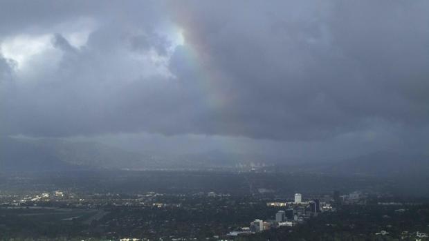
SKYCAL caught a rainbow in Encino, signaling the end of the bomb cyclone and atmospheric river that doused the Southland over night.
Heavy rain causes number of downed trees throughout Southland
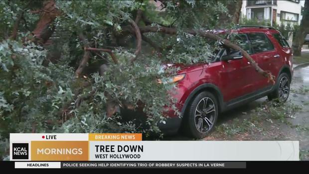
A large number of downed trees were reported throughout the Southland on Thursday, as soaked soil allowed roots to rip from the earth below.
Trees were reported down all over the region, including Burbank and Beverly Hills, as well as Somas in Ventura County.
Additionally, a giant eucalyptus tree fell onto two vehicles in West Hollywood Thursday morning, and a century-old Jacaranda tree fell on one Sherman Oak man's home.
Flooding concerns remain in coastal communities with high surf expected
Though the storm has started to move on from Southern California, flooding concerns remain high in coastal communities due to high levels of surf expected through Friday.
Residents took action Thursday, filling sandbags and helping build additional berms along the beach in hopes of protecting homes and businesses in the area.
For more on flooding preparations in Seal Beach and other coastal cities, click here.
Portion of Mulholland Drive closed as earth gives way
Six Flags closes early due to weather
Six Flags Magic Mountain announced that the park would be closing earlier than normal on Thursday, due to lingering weather in Valencia.
Officials noted that all tickets purchased for the day will be allowed on any other regular operating day through the end of 2023.
Topanga Canyon closed due to large boulder in roadway
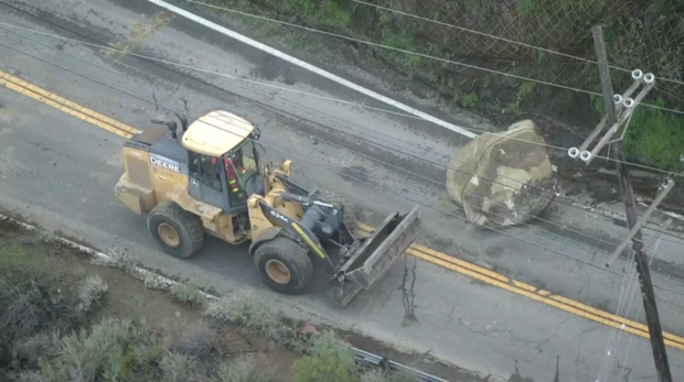
SKYCAL flew over Topanga Canyon Road, where a large boulder had fallen onto the roadway calling for a temporary closure as crews worked to remove the obstruction.
Santa Clarita roadways flood due to heavy rain
With heavy rain dousing the Southland early on of Wednesday, some parts of the area experienced flooding, including Santa Clarita.

Roadways in Sand Canyon and Canyon Country saw some roadways covered in water, where currents were strong enough to move parked vehicles.
Orange County sees flooding along coast
Multiple crashes, road closures reported all across the Southland
Multiple crashes and road closures were reported all across the Southland due to severe weather Thursday morning. Check your commute at CBSLA NEXT Traffic here.
California Highway Patrol shut down the Sepulveda Basin due to flooding: Burbank Blvd. was closed from the 405 Freeway to Balboa Blvd.; and Woodley Ave. was closed from Burbank Blvd. to Victory Blvd.
Pacific Coast Highway was closed between Warner Ave. and Seapoint St. due to Huntington Beach flooding.
One fatality was reported at the scene of a crash on the eastbound I-10 Freeway at Kellogg Drive approaching Pomona. All lanes were closed during the Sigalert, which was canceled by 7:55 a.m.
Multiple power outages were also reported Thursday morning.
Full closure of eastbound I-10 Freeway at Kellogg; Fatality at scene
All eastbound lanes of the I-10 Freeway were blocked at Kellogg Drive approaching Pomona for an unknown duration at about 5:30 a.m. Thursday.
One fatality was reported. The victim was pronounced dead at the scene, according to the California Highway Patrol.
The Sigalert was canceled by 7:55 a.m. and lanes were reopened to traffic.
Slick roads, fog on 15 Freeway heading into Cajon Pass
Rick Montanez reports from the 15 Freeway at the 215 Freeway interchange heading into the Cajon Pass early Thursday morning as weather conditions worsen.
Standing water in lanes is affecting traffic on the 15 Freeway through the Cajon Pass. The severe weather is prompting advisories to avoid driving until Thursday night if possible.
Storm could cause flight delays, cancelations
Tree topples onto home in Studio City
A tree fell onto a home in Studio City on Wednesday, as a strong storm begins to move into the Southland.
The incident was first reported at around 6:40 p.m. at a home on Fryman Road.
Los Angeles Fire Department crews rushed to the scene, where no injuries were reported.
It was still unclear if the storm caused the tree to fall and how much damage the home suffered.
Crews had cleared the area by 9:40 p.m.
Hermosa Beach Pier closes in anticipation of winter storm
The Hermosa Beach Pier is now closed until the winter storm passes through Southern California.
The closure begins Wednesday night at 10 p.m. and will last for the duration of the storm surge.
Evacuation orders issued for residents living near Alisal, Thomas, Cave burn scars
With potential flooding and debris flow heading to foothill communities due to a looming atmospheric river heading towards the Southland, San Bernardino County officials have issued evacuation orders for residents living closest to problem areas.
The order was issued for residents living close to the Alisal Fire, Thomas Fire and Cave Fire burn scars.
Residents were advised to leave immediately.
Over 4,000 LADWP customers without power
Over 4,000 Los Angeles Department of Water and Power customers had their lights cut off as the storm makes landfall in Southern California.
Here is an index listing some of the affected areas:
- Cypress Park: 2,065
- Highland Park: 1,074
- Pacific Palisades: 1,027
- Encino: 426
Everything you need to know about atmospheric rivers
Atmospheric rivers are long regions in the atmosphere that transport water. The water vapor they carry is roughly equivalent to the average flow of water at the mouth of the Mississippi River, according to the National Oceanic and Atmospheric Administration. So, when they make landfall and release all that water, they can cause extreme flooding.
They are an important part of the world's ocean water cycle, often contributing to water supplies, NOAA points out. Yet they can also bring destruction.
In addition to heavy flooding, atmospheric rivers can also cause landslides and strong winds that can knock over trees and power lines.
What is a bomb cyclone?
A bomb cyclone, also known as bombogenesis, is a fast-developing storm that occurs when atmospheric pressure drops at least 24 millibars over a 24-hour period, the National Oceanic and Atmospheric Administration note online.
A bomb cyclone occurs when atmospheric pressure at the center of the cyclone drops rapidly. In order to approximately qualify, the pressure needs to drop about 1 [millibar], or more, every hour over a 24-hour period," John Moore, a public affairs specialist and meteorologist for the National Weather Service, told CBS News.
"This can happen when a cold air mass collides with a warm air mass, such as air over warm ocean waters," NOAA explains.
When a bomb cyclone hits, the impact can vary based on location and the intensity of the storm itself. Along with strong winds, the storm can bring heavy precipitation to the point that visibility is reduced and flooding may occur, especially in coastal regions, according to the agency.
Residents are advised to be on alert and prepared to evacuate their homes at any given moment due to the propensity for flooding.
Along with the rain, people can expect high-powered winds and abnormally low temperatures.
Caltrans activates statewide electronic signs, advises against travel
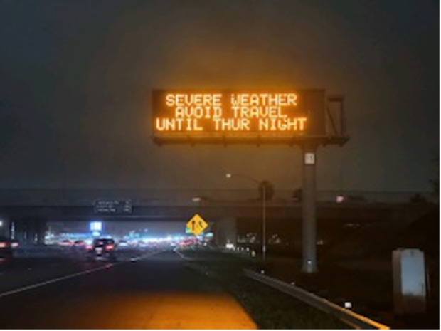
As an atmospheric river move down the Golden State, bringing heavy rain and dangerous conditions, the California Department of Transportation is activating electronic highway signs throughout the state to offer a warning to drivers.
The signs, of which there are around 1,200, will display urgent safety messages.
"Safety is always Caltrans' priority, so as a violent storm deluges our state, today we activated our electronic message signs to advise everyone to avoid unnecessary travel during the peak of the storm," said Caltrans Director Tony Tavares. "If travel cannot be postponed, we urge motorists to drive slowly, allow themselves plenty of time and be especially alert."
Additionally, Caltrans activated district emergency operation centers, working with local authorities to respond to any impact the storm may have.
Tips on how to stay safe on the road during this upcoming storm
Driving in the rain is not always easy - and let's face it, those of us living in Southern California are not at all used to wet roads.
According to AAA, bad weather causes nearly 500,000 and more than 2,000 road deaths every winter.
Evacuation orders issued in Ventura
Ventura city officials issued evacuation orders for Ventura Beach RV Resort, located at 800 W. Main Street, due to potentially high flows of water along the Lower Ventura River, which may result in flooding.
Campers could be seen packing up and heading out of the campground after the order was made.
Coastal communities, foothill regions preparing for heavy rain
With heavy rain expected as soon as Wednesday evening throughout the Southland, coastal communities are busy preparing for the worst — but hoping for the best — as an atmospheric river looms.
A high surf advisory was placed into effect, causing city officials to jump into action in places like Seal Beach as waves potentially larger than any seen in recent years could hit the coast of SoCal.
"We're gonna be watching the rainfall, the amounts, see where it's pooling, see if the rising surf and rising tides are gonna get on top of that," said Seal Beach Marine Safety Lieutenant Chris Pierce. "If it does we're gonna have people out there. We have our water pumps in the right places that we can activate, so we can kinda dewater those areas. All we can do at this point is kinda watch and react to what the weather throws at us."
Water pumps were placed in locations like Seal Beach, specifically low-lying areas where flooding was likely.
Crews had already implemented a sand berm, as usual during winter, in the event of high surf that could reach homes along the shore.
In places like Canyon Country, residents were gearing up outside of their homes and businesses.
Their proximity to burn scars, like those of the Sand Fire and Tick Fire, which both raged in the area in recent years, places them at risk of debris and mud flows.
Neighbors hope that the hillsides will hold, especially since there hasn't been much rain in the region since the fires burned.
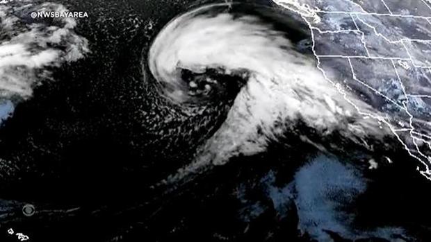
Another atmospheric river is headed for California. What's behind these damaging storms?
Another "atmospheric river" is expected to bring widespread flooding to parts of California this week — and it's not the first time the strong, damaging weather phenomenon has wreaked havoc in the state in recent days. The atmospheric river forecast to hit the region this week will be the third since Dec. 26.
And the latest storm is expected to be even more intense than the last:
"To put it simply, this will likely be one of the most impactful systems on a widespread scale that this meteorologist has seen in a long while," read a statement from the National Weather Service's Bay Area office. "The impacts will include widespread flooding, roads washing out, hillside collapsing, trees down (potentially full groves), widespread power outages, immediate disruption to commerce, and the worst of all, likely loss of human life. This is truly a brutal system that we are looking at and needs to be taken seriously."
To learn more about atmospheric rivers click here.
Gov. Newsom issues a State of Emergency ahead of storm
Governor Gavin Newsom has issued a State of Emergency to support response and recovery efforts as a large winter storm sweeps through the state.

"California is mobilizing to keep people safe from the impacts of the incoming storm," said Gov. Newsom. "This state of emergency will allow the state to respond quickly as the storm develops and support local officials in their ongoing response."
Duarte residents prepare for mud and debris flow from Fish Fire burn scar
Another storm system is sweeping in California, bringing potential flooding and debris flows.
Southern California could see up to three inches of rainfall starting Wednesday night, reaching its peak on Thursday.
Because of this, the Los Angeles County Public Works issued a Phase 2 mudflow alert for the Fish Fire burn scar area starting at 6 p.m. on January 4th until 6 a.m. on Friday, January 6th. Public officials, especially those in Duarte, are concerned the loose soil in the burn scar can give way, similar to what happened after a fire in 2016.
"Basically, we're trying to prevent anything or any objects such as a vehicle or trash can from becoming torpedoes going down in the storm," said Duarte Public Safety Manager Larry Breceda.


