Thursday brings excessive heat, severe weather threat to Metro Detroit


A heat advisory and the threat of severe weather continue into Thursday for much of the Great Lakes and Midwest, including in Michigan.
The weather conditions this week resulted in at least two tornadoes touching down in Michigan on Tuesday, with additional tornado warnings issued in the state on Wednesday. Thousands of people across the state lost power on Wednesday, although the impact was more noticeable in Mid-Michigan and West Michigan rather than in Southeast Michigan.
The CBS News Detroit weather team has declared Thursday to be a NEXT Weather Alert Days, stepping up forecasts and announcements as needed.
A tornado watch is in effect for most of Southeast Michigan through 2 a.m. Friday, according to the National Weather Service.
Across the country
The latest National Weather Service maps show parts of Iowa and Illinois, including Chicago, in a moderate risk zone Thursday for tornado activity. Moderate is a level 4 out of 5 in the severe weather risk categories.
A tornado watch was issued early Thursday and will remain in effect until 3 p.m. local time Thursday for parts of Iowa, Illinois and Missouri; with multiple tornado warnings invoked in that region during Thursday morning. A severe weather watch means "be prepared." It is possible that weather will reach severe levels during the time frame specified. A severe weather warning means "take action" because severe weather conditions have been reported by spotters or can be detected on radar.
Heat advisory in Southeast Michigan
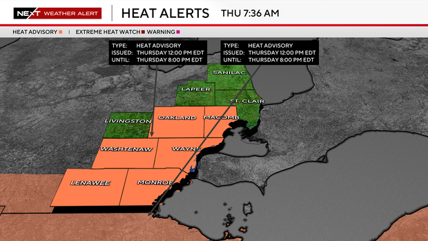
A heat advisory is in effect Thursday across part of Southeast Michigan, including Lenawee, Macomb, Monroe, Oakland, Washtenaw and Wayne counties. This is the second day in a row for the National Weather Service to issue a heat advisory in the area.
This reason is that hot and humid air will push afternoon temperatures into the upper 80s and lower 90s, with heat index values reaching the upper 90s to near 100 degrees.
Residents are encouraged to stay hydrated, limit strenuous outdoor activities during the hottest part of the day, and take frequent breaks if spending time outside.
Many of the Metro Detroit communities that opened cooling shelters on Wednesday will also offer those services on Thursday for area residents who need an air-conditioned respite from the heat.
Severe weather threat in Southeast Michigan
The heat and humidity will also help fuel a threat for strong-to-severe thunderstorms on Thursday night.
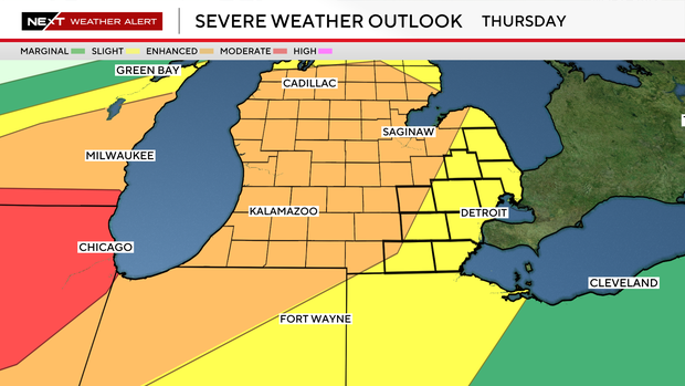
Much of Michigan's Lower Peninsula, including Lansing, is in the enhanced risk zone for storms Thursday night. That's a level 3 out of 5 on the National Weather Service severe weather risk categories.
Metro Detroit, including an area from Monroe to Port Huron, is in the slight risk zone, which is a level 2 out of 5 on the severe weather risk categories.
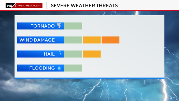
The storms are expected to develop along an approaching cold front, with the primary hazards including damaging wind gusts, large hail, torrential rainfall, and the potential for an isolated tornado.
Stay informed with CBS News Detroit
Should circumstances warrant, the CBS News Detroit weather team will livetrack the storm. You can follow the reports on air, online, on our mobile app and on our social media accounts such as YouTube.
If you wish to share photos or videos after a storm passes through, please join our Weather Watcher Network.


