Colorado Weather: A deluge of rain is coming to parts of the state causing flash flooding concerns
After mostly dry weather on Monday, typical summer chances for afternoon and evening showers and thunderstorms return to the forecast on Tuesday.
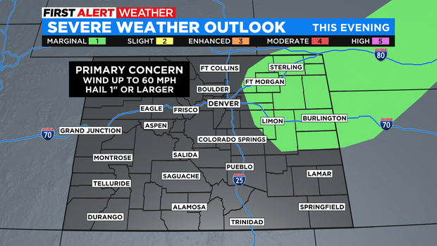
The Denver, Boulder, and Fort Collins areas have a 30-40% chance for rain on Tuesday and a similar chance on Wednesday. By early evening both days, most of the thunderstorm activity should be on the Eastern Plains where a couple storms could be severe with large hail and/or damaging wind. No severe weather is expected in the metro area.
Then looking ahead to Thursday, monsoon moisture will combine with an usually strong cold front to bring the coolest and wettest day in weeks to many areas.
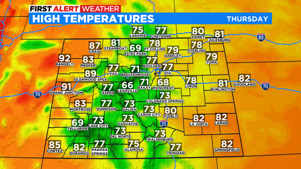
High temperatures on Thursday will only be in the 70s at lower elevations and 60s in the high country. It should be the coolest day in Denver since June 26th.
Rain is not expected all day on Thursday but most areas will experience wet weather especially in the afternoon and evening. Some weather models suggest some areas around Denver could get more than 1 inch of rain while parts of southern Colorado get more than 2 inches. Denver averages only about 15 inches of precipitation a year so that much rain in a single day is welcomed so long as it doesn't arrive all at once and causes flooding.
Because of the high likelihood for rain that may be heavy times and cause flooding, CBS News Colorado has declared Thursday a First Alert Weather Day to emphasize the need to pay attention to the forecast.
Friday also has the potential to be wet at times followed by gradually drier and warmer weather for the weekend.