High fire danger, wind, rain and snow move across Colorado to end the week

A buffet of varying active weather conditions is expected across Colorado for the rest of this week.
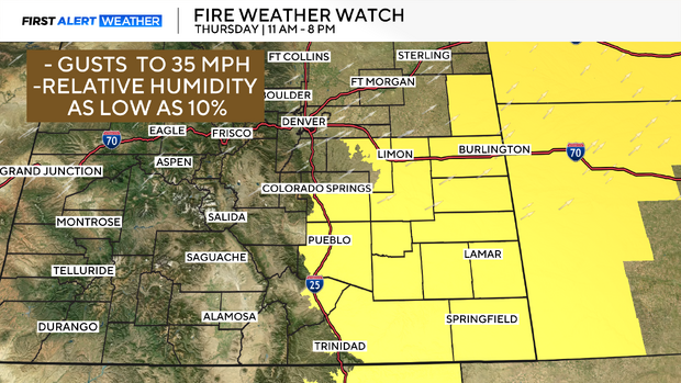
Warm & dry Wednesday and Thursday, wildfire concerns
Wednesday will be mild and dry once again across all of Colorado. Bone-dry air and above-average temperatures will heighten fire concerns, but wind gusts will stay well below the threshold for any widespread fire alerts. Temperatures will peak in the 60s and 70s on Wednesday afternoon.
Another surge of warmth is expected on Thursday, with 70s and even 80s possible on the far Eastern Plains. Wind gusts will also pick up along and south of Interstate 70 on the plains. This will create high fire danger, and Fire Weather Watches have already been issued from 11 AM to 8 PM Thursday. Please use extreme caution and common sense.
Rain and snow arrive to the mountains Thursday night
Rain will quickly shift to snow across the southwestern parts of the state late Thursday afternoon. Widespread moderate to heavy snow is expected overnight and into the morning commute along the mountain corridor of I-70 and mountain passes. Significant slowdowns and potentially even closures are anticipated for the Friday morning commute.
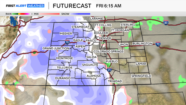
While all of this unfolds in the high country, it'll be the calm before the storm across the Front Range. Rain is expected to start by late morning from Fort Collins to Trinidad.
It's looking increasingly unlikely that rain will transition to snow for many across the Front Range due to:
- A very fast storm speed, organizing too far to the east (this is what happened with our last potential blizzard).
- Warm temperatures as the storm arrives; the atmosphere will need to cool for snow to occur (the later the transition, the less snow).
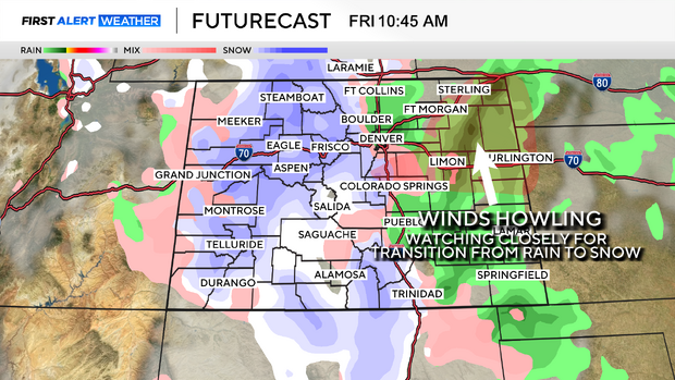
The one area to keep an eye on is the Palmer Divide and northeast plains.
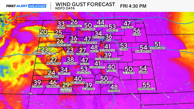
Windy Friday across Colorado
It will be a breezy end to Thursday and start to Friday, with winds really beginning to whip by Friday afternoon. As of now, data suggests the strongest gusts will max out around 60 MPH. Given how rapidly the low-pressure system will intensify to our east, I suspect this gust potential will increase as we near the end. With that said, a high-wind day is possible come Friday.