Colorado braces for heavy rain and snow, Denver will see the heaviest rain on Tuesday

Spring slop is heading to Colorado, bringing snow to the mountains and heavy rain to Denver.
The first round of moisture will arrive Sunday night and slowly spread across the state on Monday. Rain and snow will spread south of I-70 through 11 AM and northward by 1 PM.
While precipitation will remain all rain for the Eastern Plains on Monday, this will result in accumulating snow across the San Juan, Sangre de Cristo, and Sawatch Ranges.
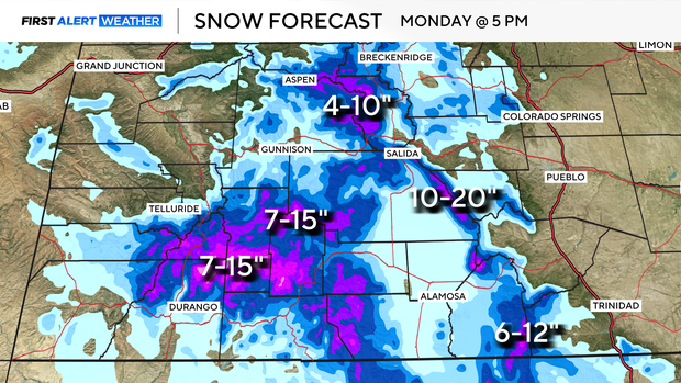
Rain will continue on and off all day on Monday. After a brief lull overnight from Monday into Tuesday, heavy rain and snow are expected across nearly the entire state. Rain/snow lines will drop as low as 8,500 feet on Tuesday during the day, leading to significant snow accumulations at higher elevations.
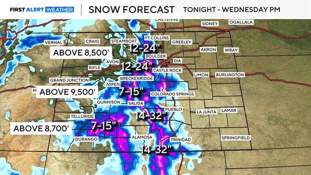
For example, along I-70, Idaho Springs is expected to receive 2 inches of snow, while the Eisenhower Tunnel could see 14–18 inches. Areas between approximately 6,500 and 8,000 feet may toggle between rain and snow on Tuesday night, which I will continue to monitor closely.
While all of this is happening across the high country, a soaking rain will bring much-needed moisture to the rest of the state. We're lucky enough to display a rain totals map about once a year, and this is one of those times. Widespread 1–3 inches of rain are expected.
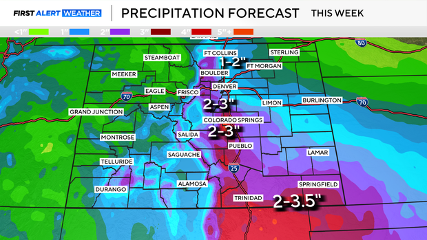
Urban flooding will be possible on Tuesday across much of I-25.