Colorado Weather: Blizzard Warning In Effect As Biggest Snowstorm In 15 Years Hits Denver
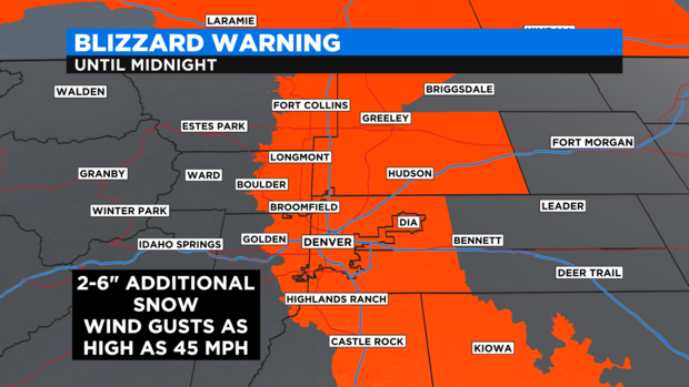
DENVER (CBS4) - The winter storm slamming Colorado was upgraded to a blizzard early in the afternoon on Sunday. A Blizzard Warning was issued for Denver and the the entire Front Range through midnight Sunday for very difficult to impossible travel conditions. The storm has officially dropped more than 2 feet of snow in Denver.
Additional snowfall between 2 and 6 inches will combine with wind gusts up to 45 mph to create extremely limited visibility across the Denver, Boulder and Fort Collins areas.
As of 7 p.m. on Sunday, Denver had officially measured 24.1 inches of snow and had over 1.07 inches of liquid precipitation. This storm is now the biggest snowstorm to hit the Denver metro area since at least the first of back-to-back blizzards hit before and after Christmas in 2006.
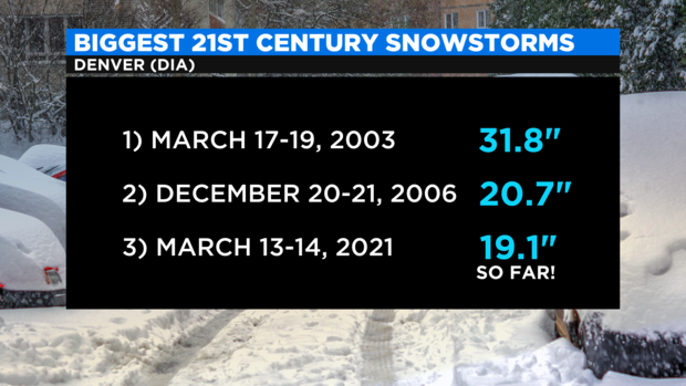
It is likely Denver will exceed the total from the 2006 storm (20.7 inches) by the end of the day on Sunday. Which means this blizzard will be the worst since the major blizzard in March 2003.
Most of the Denver metro area will see another 4 to 8 inches of heavy, wet snow through Sunday evening. Most of that will fall through early afternoon on Sunday.
A Winter Storm Warning is also in effect through 6 a.m. Monday for most of the mountains and parts of the Eastern Plains. Locations in the foothills of northern Jefferson County, Boulder County, and Larimer County including Genesee, Black Hawk, Nederland, Estes Park, and Red Feather Lakes should see 10-15 inches of additional snow through Sunday night.
The mountains east of Vail Pass are expecting another 6 to 12 inches of snow including for ski areas like Breckenridge, Keystone, Copper Mountain, Loveland, and Winter Park. Amounts should be somewhat less of Vail Pass with 3 to 7 inches of additional snow for Aspen/Snowmass, Crested Butte, Vail, and Beaver Creek.
Meanwhile, Winter Weather Advisories continue for many other areas around the state with additional accumulation expected in all areas under an advisory.
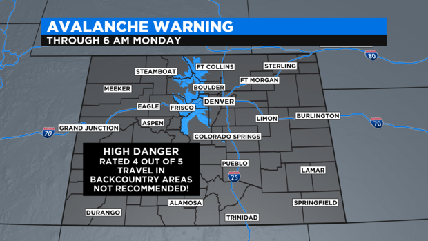
The extra heavy snow in the mountains has contributed to raising the avalanche danger in Colorado. An Avalanche Warning continues through 6am Monday for most of the central mountains in the state. The danger is "high" which is level 4 of 5.
Another storm will approaching Colorado on Tuesday with a chance for snow in the metro area starting in the afternoon. Accumulation is possible but it will be much less compared to this weekend.
RELATED: Colorado Is Known For Heavy March Snow, One Storm Ended Record Drought In 2003
Farther north, a Blizzard Warning also continues through 6 a.m. Monday for up to 30 inches of snow combined with wind gusts up to 60 mph in southeast Wyoming, the panhandle of Nebraska, and even the Black Hills region in South Dakota. Travel is essentially shut down across this region.


