Easter Weekend Weather Forecast: Rain Saturday, Better Sunday
You can expect a rainy Saturday, with steady rain falling in the morning and early afternoon. It should taper somewhat in the evening.
Watch CBS News
You can expect a rainy Saturday, with steady rain falling in the morning and early afternoon. It should taper somewhat in the evening.

Chilly winds will let up later tonight and diurnal cumulus will melt away leading to ideal radiational cooling conditions and temps in the 20s and lower 30s by morning across all of Eastern and Central Mass

It has been a gloomy stretch lately and this Easter Weekend may not be a whole lot better.
After two days of cloudy, raw conditions tomorrow the sun returns...yeah! A coldfront is working out of the Hudson Valley and into the Berkshires right now...along some dying showers and a windshift that will finally dry us out.

After our long, tough winter, robins are a reassuring sign of spring. But they're also raising a question.
This is so typical of Spring in New England and while I'm not a fan of this, for me, I just think back about 45 days ago when the snowbanks were up to our ears and a smile appears on my face...I'd take this any day of the week over that!
What a day...weather was pretty good, sox win, great marathon...maybe we can keep this going tonight with a big B's Win...just maybe! As far as the weather goes, it is all down hill from here, clouds are thickening and sprinkles are falling now and we will see periods of rain over the next couple of days.
All of a sudden there is a lot of color in the landscape...yesterday's rain and today's sun has after blooming. The grass is green the Forsythia is out and the Magnolias are blooming...it all looks great!
It seemed like everyone was in a funk today and it probably had everything to do with the rain...after all there was a lot. Amounts exceed 5" on the Upper Cape in Falmouth and Sandwich and well over 4" on Martha's Vineyard.
Overrunning rain is beginning to break out well ahead of the surface and upper level lows. Lower levels of the atmosphere are very dry right now but will steadily moisten up so eventhough the radar looks very impressive the rain will be pretty light...for now.
A coldfront is marching our way from the west...convection is popping out ahead of it and will weaken as it works into Southern New England but some leftover showers and rumbles will be possible later tonight
The atmosphere will be undergoing a transformation and will be warming up quite a bit over the next few days. While temperatures aloft will be similar to Summer levels it is always tough this time of year to get that warmth to translate to the surface. We will be dealing with seabreezes and cloud cover and most critical of all...wind direction.
It was a beautiful day and plenty warm enough in my opinion but near the coast you could definitely feel a chill due to a weak seabreeze.

We never had a winter thaw and really haven't been able to put together a string of unseasonably warm days this spring yet either. Until now.
Another one of those deceptive days where it looks much warmer than it actually feels outside...especially when those clumps of clouds rolled in.
The high today was 64 degrees set just after noon and just before the coldfront swept through. Following that, temps tumbled most of the afternoon and we are now in the 40s and 30s!

Tree buds are a welcome sign of spring. Unfortunately, spring also signals the return of the dreaded winter moth.

Heavy, wet snow fell at sunrise on April Fools' Day, letting everyone know this nagging winter isn't quite over yet.

Temperatures are so borderline that a difference of just one or two degrees could mean very little snow or several inches.
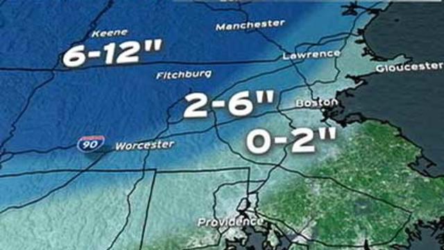
There will likely be a significant, heavy and wet snow in parts of northern Worcester County, all of western Massachusetts and in southern New Hampshire.
All-aboard...that's what most major models did over the last 24 hours indicating a major Nor'easter for Friday! This doesn't mean we will take a direct hit but the chances are growing.

There are signs that we could be in for a sizeable storm Friday. The problem is, many weather models are still having a tough time putting all the pieces together.
At least we have the sunshine and that will continue to dominate through the middle of the week. The airmass will begin to moderate too
Still seeing some pretty intense snow showers out there this evening but now that the sun is setting these will gradually dry up and the clouds will begin to clear out.