Slight Shift in the Forecast...
Watch CBS News
We've had several reports of flurries and a little light snow this evening but nothing is sticking yet as surface temps are still above freezing and the snow is pretty much negligible anyways.
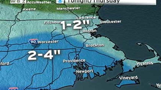
Most of us will wake up to an average of one-to-three inches of snow on Thursday morning. It will be more of a nuisance than anything else.
Well the pattern is reverting back to Mid-Winter so it's only fitting that the models revert back to their Mid-Winter form too. Basically the NAM and GFS have flip-flopped with the GFS now the most robust model and the NAM backing off pushing the precip mostly well south of us.
It's ironic that as we finally welcome spring that we revert back to a pattern similar to that one which caused us so much angst in mid-winter.
Downstream blocking that we had earlier this Winter is setting up again and looks to hold strong through the rest of the month. The NAO index is trending negative leading to a build up of cold air in Eastern North America. The result, colder than average temperatures and more chances for snow.
Today's high tied the record set back in 1999 of 70...we hit it at about 3:15PM. Obviously the warm air was a headline grabber but the wind was one too...and maybe a bigger one!
These kind of days are few and far between...usually something messes it up like a seabreeze or cloud cover blocking out the warm sun but not today!
Had the privilege to view the Boston Flower and Garden Show this evening...beautiful sight that will surely jumpstart you into Spring
Welcome to the last week of Winter...My heart fluttered a few times seeing the snow today...uhhhhhhhhhgggggg...hopefully that was the last flake of the season. It will likely be the last flake of the week but t here will be opportunities for precip.
It 's been one historic day...obviously, our thoughts are dominated by the Natural disaster that occurred in Japan and the people of that nation. It truly is amazing the power, force and on some strange level, the beauty mother nature occasionally displays...mesmorizing!
Very little rain has fallen in the area today so we wait...
We just strung two consecutive dry days together...can we make it three...no.
I left my house about 15 miles from Boston and the coast early this afternoon and the temp was 43,

Rain-swollen rivers and streams spilled into streets and neighborhoods in Massachusetts and New Hampshire on Monday.
Spending the weekend above freezing and watching lots of snow melt away was nice but now we are starting to pay the price...
I had the my first taste of Spring this evening...maple syrup...fresh out of the evaporator...good stuff!
As suspected yesterday...MOS guidance for today was way too low...the temp made it up to 29 at Logan...again, 850mb temps is the way to go. We bottom out tonight then we go on a warm streak
A brief shot of Mid-Winter cold will move in tonight ushered in by gusty NW Winds...some serious cold air advection willtake place with a near 40 degree temp drop from the high today (48) to the low tomorrow morning!
Chief Meteorologist Todd Gutner recently paid a visit to Memorial Elementary School in Upton.
I went out to Upton to visit with the 2nd graders at Memorial Elementary School today and noticed that the ice on all the lakes and ponds heading out to Upton had some beautiful ice on them...
Low pressure traveled to our West today but the warmfront wasn't able to penetrate deep into New England...in fact it stalled over SE Mass where the snowpack is limited or even gone!
Temps are falling...nothing drastic but enough to change rain to snow as the atmospheric structure is cooling from above to the surface.

With a fresh 6-12 inches of snow set to fall in northern New England, skiing should be great this weekend. Todd Gutner reports.
Spring surging up from the south Winter hanging around to the north...the two will be doing a nice little dance over the next several days...