Upping The Snow Totals, Intensity Of The Storm
Our first widespread snow event including Boston and points south since February of 2011!
Watch CBS News
Our first widespread snow event including Boston and points south since February of 2011!

Yesterday Northern New England got hit hard by snow, tomorrow it will be Southern New England's turn.
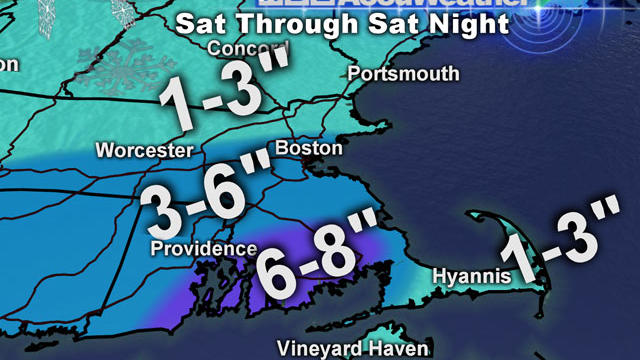
Some of our latest weather models are projecting the Saturday storm to be a bit juicier and taking a path slightly closer to the coast of Massachusetts.

It was a very stormy day and we saw it all...damaging wind and battering waves along the coast...flooding rain in Eastern MA...and heavy snow for the Interior.

Models have had a difficult time thus far nailing down a track for this one, but at this point I see two potential scenarios for Saturday.
An area of low pressure is rapidly developing to our south and spreading moisture into New England.

A major winter storm is on the way to New England, one that has ravaged the South with numerous tornadoes and covered much of the Midwest in blizzard conditions.
Today was the first day of Winter yet Pittsfield, MA with a high of 49 degrees was the only official site to not record a high in the 50s today.

The most popular question to our weather team lately - "Is there any chance of a white Christmas?"
Although it didn't rain today it was still tainted by the gusty conditions...numerous gusts over 30 mph.
A coldfront is working through New England tonight, we may see another shower or two with the passage but late tonight the air will dry out as winds pick up out of the NW.
We are in an active pattern with multiple storms rolling through New England this week...sadly for snow lovers and those craving a white Christmas, each storm will have warmer temps with it.
All the talk is of the developing stormy pattern next week but we really have been treated to some wonderful December weather these last few days...and it will continue for a couple more.
Mother Nature is offering up a perfect opportunity to get some holiday shopping and errands done this week with dry, sunny and seasonably cool conditions. However, this current pattern will breakdown by the end of the weekend and much of next week is looking stormy.
Winter's chill has returned in the wake of last night's coldfront...temps tumbled from 57 degrees at midnight to their current numbers in the upper 30s...and still falling.
Another warm storm is racing through New England. Temps soared through the 50s and into the 60s for some today...Boston topped out at 61 degrees just after 2PM, just 3 degrees shy of the record for this date.
An arctic coldfront is sweeping through the region, this is kicking off a few flurries as it ushers in some much colder air.
Today was under-achieving all morning with chilly and rain showers but by the afternoon the warm air finally worked north and now all are above 50 degrees except folks in Northern New England.

What a day...with abnormally warm air and ample sun.
A coldfront is working through Northern New England...it is triggering numerous snow showers and squalls and the mountains will pick up several inches tonight.

Storm system is pulling away but the cold has been left behind.
It has snowed off and on for almost the entire day and there is very little to show for it...
It's been one very dry stretch of weather...the last time we saw measurable rain or snow was on the 13th of the month...two weeks ago!
That was a Thanksgiving treat!

When you think of a New England winter, one thing comes to mind: snow. But research is showing our winters are changing.