Nor'Easter In Forecast For Wednesday, Thursday
The peak of the storm will be overnight Wednesday into Thursday morning.
Watch CBS News
The peak of the storm will be overnight Wednesday into Thursday morning.
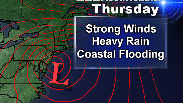
The latest thoughts are that the rainfall will tally up to 1-2 inches (isolated amounts of 3 inches) from Wednesday evening to Thursday night.
It's a tranquil start to your work and school week. Today will be partly sunny with a raindrop or two possible for the Cape and Nantucket. It's going to be chilly with highs in the middle 40s.

After the beating from Sandy and clouded subsequent days, it was nice to see a greater amount of sunshine today as temperatures reached the lower 50s in many areas.

Another storm will be making a run at New England Wednesday, according to WBZ-TV meteorologist Joe Joyce.

There is likely to be some sort of storm off our coastline by the middle of next week. How close it comes and what its track and strength will be remains to be seen.

So you may have heard… meteorologists up and down the East Coast are all on heightened alert this week. What has all of our attention? A little storm currently located about 325 miles South of Jamaica.

Remember those warm, dry and sunny March days we had? And remember wondering if we were going to pay for it at some point? Well, it is payback time.

There will be several hazardous weather conditions to deal with late tonight and Thursday morning.

The Department of Public Utilities is looking into whether the power companies were properly prepared for the storm.

National Grid says it would have been better prepared for the storm and restored power to 420,000 customers quicker had the forecast been more accurate.

The October Nor'easter we just lived through is making a lot of people nervous about the coming winter.

More than 50,000 people in Massachusetts still do not have power after last weekend's Nor'easter.

Areas in Western Mass. hit hard by June tornadoes are now dealing with power outages from the Nor'easter.

Residents who were left in the dark after Tropical Storm Irene are once again without power after a rare October snowstorm.
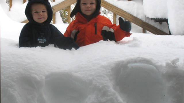
The snow totals for the October 29-30 Nor'easter ranged from nearly nothing in parts of Boston to more than two feet in parts of western Massachusetts.

The combination of high winds; the leaves still on trees; and heavy, wet snow was expected to result in widespread power outages.

Not much change at all in the forecast from last night...we are still in for a powerful and dangerous early season nor'easter.

The Massachusetts Department of Transportation has 4,000 pieces of equipment ready to respond to Saturday's storm, including plows, trucks, and sanders.

This weekend is what everyone sets their calendars by in Salem, and a white Halloween is not what anyone was expecting.

A major nor'easter is about to pound southern New England with heavy rain, snow and wind.

Heavy, wet snow fell at sunrise on April Fools' Day, letting everyone know this nagging winter isn't quite over yet.

Temperatures are so borderline that a difference of just one or two degrees could mean very little snow or several inches.
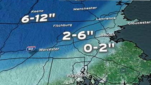
There will likely be a significant, heavy and wet snow in parts of northern Worcester County, all of western Massachusetts and in southern New Hampshire.

There are signs that we could be in for a sizeable storm Friday. The problem is, many weather models are still having a tough time putting all the pieces together.