Mother Nature In 'Relaxation Mode'
It's going to be another beautiful Fall day as clouds erode and sunshine takes hold by midday. Temperatures will be cooler as winds have shifted in the wake of the cold front.
Watch CBS News
It's going to be another beautiful Fall day as clouds erode and sunshine takes hold by midday. Temperatures will be cooler as winds have shifted in the wake of the cold front.
Yes, it was a stormy Sunday. However, we are in the midst of a dry, tranquil stretch of weather that's as long as the Boston Marathon on an April Day! :) Sunshine, sunshine, and yes, more sunshine!
Tranquil weather prevails as we mark off another day on the calendar for November 2011.
We are in a quiet weather pattern after a stormy end to October, and the 'doldrums' are here to stay for at least the next handful of days.

The main issue this evening (besides traversing through the snow) will be the cold.
Your 'treat'!!!--->The sunshine is back with a frosty start and a 'ghoul-ish' afternoon with high temperatures in the upper 40s to lower 50s

A major nor'easter is about to pound southern New England with heavy rain, snow and wind.
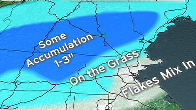
We are forecasting the first snow of the season for many folks in southern New England.
We will start to notice a changeover between rain and snow late this afternoon and this evening.

Many of us will see our first snowflakes this season before Thursday night is complete.
Today will be a beauty with gusty WNW winds. Highs will reach the upper 50s and lower 60s.
Dare I say 'snow'?!?! Yes, snow may be in the forecast later this week for the higher elevations north and west of the Boston. Until then, sunshine will prevail today as clouds begin to take over during the afternoon.

What is David Wade eating while in his car in the commercial for "Wake Up"--etc? - Jean, Leyden
Rain is the name of the game! Most of us will start the day with fog, mist, and drizzle. Heavy downpours and some storms can be expected this afternoon and this evening.
Later in the afternoon, it will be cloudy and damp along with some mist/drizzle at times.
Clouds are starting to make their mark across Southern New England. The rain is next. The air is still dry, but rain will eventually win out this evening for the southern portions of Southern New England. High temps will be cooler today within the 60-65F range.
A backdoor cold front has created a wind shift. We will continue to soak in the sunshine, but we will also have cooler high temperatures.
What a gorgeous Holiday weekend! This sunny, summerlike pattern is still in the works today!
It's going to be a sunshiny, summerlike Columbus Day weekend!
Clouds along with a few sprinkles and showers will skirt extreme Eastern Mass. and the Cape/Islands through mid-morning. Then, we can expect a sun/cloud blend through the afternoon and completely clear skies tonight.
Rain will be heavy at times this morning while it will become more widely scattered this afternoon. Highs will hover between 60-65F. The rain will come to a complete halt early tonight.
This stubborn upper level low is about to make a move out of here! We will continue with a mixture of clouds and sunshine today with a slight chance of a spot shower.
September is 'going out with a bang'! It's going to be a beauty of a day with very warm temperatures in the middle to upper 70s!
The first change is that we've gone from sunshine to clouds and showers. The massive area of low pressure that has been hangin' out in the midwest is slowly reaching our hometowns.
A persistent onshore wind will cool us down today and will also be the culprit for the potential of minor beach erosion and splashover for east-facing beaches. Skies will be partly sunny along with high temperatures in the upper 60s along the coast and lower 70s as you travel farther away from the coastline.