Fall-Like Weekend Is Coming Up
Temperatures will be taking a slight downward turn today as highs will range between the lower and upper 70s. The cooler temperatures will be along the coast as winds will originate from the E-NE.
Watch CBS News
Temperatures will be taking a slight downward turn today as highs will range between the lower and upper 70s. The cooler temperatures will be along the coast as winds will originate from the E-NE.
The foliage is starting to show explosive colors across Northern New England, but most of our viewing area won't reach peak until mid-to-late October
It seems that Mother Nature isn't easily letting go of Summer 2011. It was a very warm and almost tropical-like weekend, and the weather today will be no different.
Fall is officially here.
It's the last full day of Summer! Are you ready for Autumn?!?!
2 days and counting... Autumn arrives at 5:05am this Friday.
A deteriorating cold front will be the culprit for cloudy conditions today as well as midday showers, mainly between 11am-5pm. Highs will still be slightly below normal in the upper 60s/near 70F.
We are in the midst of our final week of Summer! Fall arrives this Friday at 5:05am.
We are waking up to warm and humid conditions, but a late-day cold front will 'wash' it away.
Summer is holding onto the steering wheel with two hands!
The summerlike stretch of weather will be sticking around through Wednesday, but a '1-2 punch' cold front will open up the gates to our first taste of Autumn later this week.
Summerlike weather is in the works through midweek, but our first taste of Autumn is right around the corner. The Full 'Harvest' Moon is this morning at exactly 5:27am.
We will have one more day of clouds, showers, and cool temperatures. Brighter days are on the weather menu for the weekend. High temperatures will only be in the 65-70F range today.
The rain began late Monday night, and the showery pattern will continue today.
The rain has moved in, and it's here to stay for the next few days.
This Labor Day is going to be warm and muggy. There will be chance of showers and thunderstorms by this evening as a cold front SLOWLY moves from west to east. Highs will be in the upper 70s to lower 80s. Winds will be gusty from the south.
Labor Day weekend is here! It's going to be another pretty day here in New England. Highs will stay in the 70s compliments of the onshore breeze. Humidity will remain low until tomorrow.
A combination of sun and clouds will be the name of the game on this first day of September. Highs will be a little cooler in the 70s compliments of the onshore breeze.
What a beauty for the last day of August! More sunshine is on tap today with low humidity and high temperatures reaching the upper 70s and lower 80s inland.
The sun will shine again today in conjunction with low humidity and high temperatures in the upper 70s to lower 80s.

Irene hit southern New England with Tropical Storm force wind gusts and heavy rain Sunday. Here are the towns hit the hardest.

The final feeder bands of rain from Tropical Storm Irene will spiral into the Boston area in the next couple hours while the steadier, torrential rain exists over northern New England.
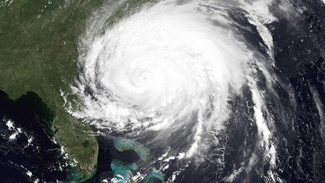
We are becoming more and more confident that New England may be in for its first hurricane in 20 years, since Bob in 1991.
We will see one more quiet day before starting to feel more and more of the effects of Hurricane Irene.
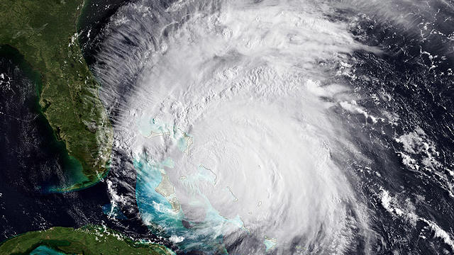
As Category 3 Hurricane Irene continues to churn through the Bahamas, folks along the East Coast are keeping a close eye on the projected path and forecasted strength.