Snow coming to Boston area again today. Weather forecast maps show potential totals in Massachusetts.
The Boston area is in the midst of a busy stretch of winter weather with two chances of snow in Massachusetts the next few days.
We've got a bit of a messy mix on the way Friday with periods of rain, sleet, freezing rain and snow throughout southern New England. This will not be a major storm, overall impacts will range from low to moderate depending on your location.
Boston weather forecast
The National Weather Service has issued a Winter Weather Advisory for areas west of Interstate 95 Friday afternoon through early Saturday.
This is for the possibility of some light snow accumulation, light icing and slick road conditions.
Winter Storm Warnings are posted in Vermont and southwestern New Hampshire. This is where snow accumulations will be highest.
If you are looking for a pure, all-snow event, you'll have to head north toward the Massachusetts - New Hampshire border or up into New Hampshire.
Milder air will rush in aloft rather quickly Friday afternoon. We do not anticipate much snow accumulation in southern New England before dark on Friday.
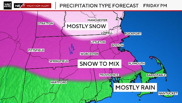
When will it snow on Friday?
A mix of rain, sleet and snow will move in during the afternoon on Friday but it will be rather spotty and unorganized.
Surface temperatures will also remain largely above freezing during the daylight hours, making it very difficult for snow to stick or accumulate.
The best chance for snow accumulation and snow-covered roadways will be later Friday night, after 8 p.m. Colder air will filter in on the backside of the storm and change any mixed precipitation over to snow. There will be scattered snow for a good portion of the overnight hours.
Even after dawn on Saturday, there could be some final snow showers or coastal flurries.
How much snow?
Coating - 1 inch: From Plymouth to Providence northward up to the Mass Pike including Boston and Worcester. (All at the end of the storm, Friday night)
1 to 3 inches: Areas north of the Pike up to about Route 2 and near the Mass./N.H. border (Mostly all Friday night)
3 to 6 inches: North of Route 2, northernmost Massachusetts and southern New Hampshire.
Ski areas in central and northern New England will love this storm, with a fresh 6-to-10 inches for most.

Boston weather this weekend
We continue to monitor model trends for an ocean storm later this weekend.
There will be a very large and powerful storm developing off the Carolinas on Sunday. It will rapidly strengthen and deepen as it travels northeastward on Monday.
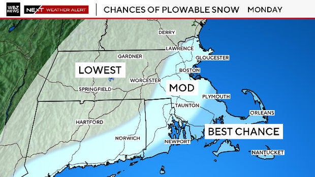
While a direct hit and worst-case scenario is still possible here in southern New England, we feel as though that scenario is fairly low-likelihood, about a 20% chance.
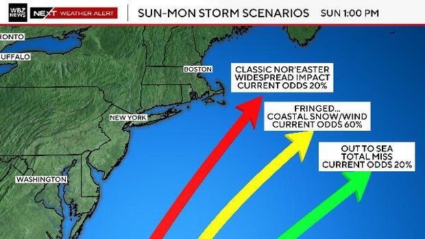
We are still leaning toward a track that would bring the center of the storm just a bit too far south and east for major impacts here.
Under that scenario, portions of southeastern Massachusetts would be at greatest risk for "fringe" impacts.
This could still lead to a plowable snowfall and very gusty winds over Plymouth County, Cape Cod and The Islands.
The farther north and west you live, the lower the odds of any significant impact on Monday.
The WBZ NEXT Weather Team will have you covered on WBZ-TV, CBS News Boston and WBZ.com every step of the way.