Nor'easter impacting Boston weather. Maps show potential for heavy rain, gusty winds.
Nearing Memorial Day weekend, a nor'easter like the one impacting weather in Boston and across Massachusetts is a fairly rare occurrence. But in the month of May, it's not completely unheard of.
You may remember four years ago, when a late season nor'easter completely washed out the entire 3-day holiday weekend.
At least this year, the main impacts from the storm will be before the weekend arrives. Unfortunately, we cannot issue the "all clear" for the entire upcoming weekend, more on that in a bit.
Our weather team has issued a NEXT Weather Alert for Thursday.
When does the rain arrive?
The main impacts will be heavy downpours, localized flooding, strong winds and some minor coastal flooding.
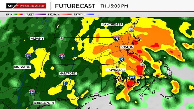
The brunt of the storm will occur between about noon and midnight on Thursday.
Massachusetts Weather Radar
Thursday AM commute
The shield of rain is moving from southwest to northeast. Steady rain arrived in Worcester County area between 4 to 7 a.m. and in Boston and eastern Massachusetts between 6 to 9 a.m.
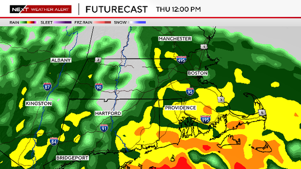
Thursday lunchtime
The heavy rain arrives from south to north. The winds also begin to ramp up, gusting over 30 mph along the Coastline and over 40 mph on the Cape and Islands.
Thursday PM commute
The peak of the storm. The downpours continue and now, pockets of localized flooding will be present along with some big puddles on the roadways. The winds will be near peak with gusts of 30-50 mph across most of eastern Massachusetts.
Thursday night into Friday AM
The rainfall pivots northward after midnight and by Friday morning's commute, most of southern New England is dry or drizzling. We gradually dry out during the rest of Friday.
How much rain?
Most areas will receive between 1-2" of rain. There will likely be pockets with as much as 3".
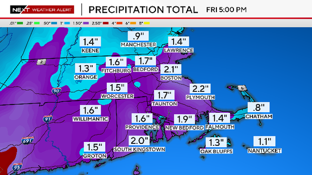
This will not be enough to cause any major river flooding; however, some smaller rivers and streams may approach their banks once again.
Winds ramp up
As mentioned above, the winds will ramp up Thursday morning, peak during Thursday afternoon and evening, and then slowly ramp down overnight.
Maximum gusts will occur along the immediate Coastline (up to 50mph).
The National Weather Service has issued a Wind Advisory for the entire east coast of New Hampshire and Massachusetts on Thursday from 11 a.m. to 11 p.m.
Flooding concerns
Our tides are approaching one of their highest astronomical levels of the year, set to peak on Sunday and Monday.
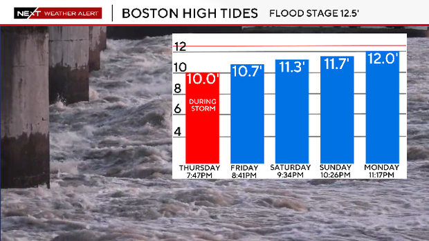
Thankfully, tides are not forecast to be high enough on Thursday to cause any major issues. There will likely be some minor flooding and splash over during the Thursday evening high tide (occurring between 7-8 p.m).
The National Weather Service has issued a Coastal Flood Advisory for the entire New Hampshire, Massachusetts and Rhode Island coastlines Thursday 6-11 p.m. (4-7 p.m. on the South Coast).
Memorial Day weekend forecast
The nor'easter will be slow to depart and therefore we expect some lingering, minor impacts into the upcoming weekend.
Conditions will improve each day, with more sunshine and warmer temperatures expected by Sunday and Monday.