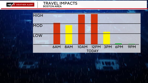
Ice and freezing rain could cause major problems on Massachusetts roads Wednesday
Ice and freezing rain could have major impacts on roads, driveways and sidewalks in Massachusetts Wednesday morning.
The WBZ Weather Team has issued a NEXT Weather Alert for the icy, wintry mix.
Storm timeline
The precipitation began Tuesday night. It will stay light and spotty for the most part, continuing through Wednesday morning.
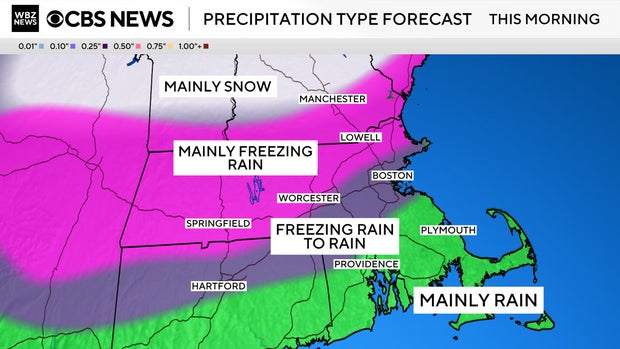
Depending upon where you live and travel, the impacts and precipitation types will be vastly different.
South Shore, South Coast, Cape Cod and the Islands: Mainly rain, very little concern for icing.
North Shore, Boston and most of the area inside 495: Starts as freezing rain. Most of this area is near or slightly above freezing by Wednesday morning, changing over to plain rain.
495 belt from Lawrence to Lowell to Marlboro to Worcester and areas north and west: These areas are likely to stay near or slightly BELOW freezing for the entire duration of the storm. Therefore, we expect mostly freezing rain and ice accretion on surfaces as high as .1"-.2". Temperatures will tick above freezing around midday or early afternoon here.
Central and Northern New England: Good news for ski areas as this storm will be mainly snow up north.
By the afternoon commute, the storm will be over and most areas will be in the mid 30s with just a slow tick downward overnight (no flash freeze).
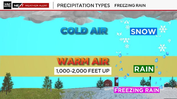
What is freezing rain?
A quick explainer on freezing rain: Think of the atmosphere as a giant layer cake. Much of the top section (above about 2,000 feet) is quite cold Wednesday, well below freezing and certainly cold enough for snow to come out of the clouds.
As that snow falls, it will pass through a rather thin layer (between 1,000 and 2,000 feet) where temperatures are slightly above 32 degrees. As the snowflakes pass through this section, they melt into rain drops.
Finally, down at the ground level where we live, temperatures for much of the overnight will be below freezing. So, when the rain falls into this bottom layer and hits the ground, it tends to refreeze on contact creating an icy glaze over everything.
Here is another view, again picturing the atmosphere above us as a layer cake.
Freezing rain can be one of the most hazardous types of precipitation for those traveling by foot or by car.
Don't assume that the roads are clear of ice just because your car thermometer reads 33 or 34 degrees. Some areas may take longer to warm up than others...bridges, overpasses and low-lying areas may stay below freezing for much longer periods of time than surrounding areas.
Leave yourself extra time to get to work. Take it slow and be cautious.
Watch that first step out the door. Your driveways and walkways may also be icy. Finally, be prepared for the car door and wipers to be iced over. It will be a good morning to use that remote starter if you have it.