More snow? Here's what to know about storms for Boston and Massachusetts this week
BOSTON - A mix of snow and rain moved through Massachusetts Thursday and there's another storm in the forecast for the Boston area this weekend.
Snow, sleet, freezing rain and rain have made for a messy morning commute. While we won't be getting a whole lot of any of the above, it is just enough to cause some travel headaches early on Thursday.
Snow changes over
Up first, the snow. First flakes arrived around 10 p.m. on Wednesday. The snow struggled to accumulate and make any real impact. For the first few hours it was light and spotty, leaving just some scattered coatings.
By the time the precipitation got steadier, warmer air began moving in aloft. The snow quickly changed to a mix of sleet, freezing rain and rain right around dawn. At the coastline and across much of eastern Massachusetts, the snow went right over to rain. There will be some lingering pockets of freezing rain north and west of 495 and up in southern New Hampshire.
The steady precipitation end and around noon and we will be left with mostly scattered rain showers
How much snow?
Snowfall totals are almost not worth mentioning. Most folks in southern New England won't even know that it snowed overnight. The coatings will quickly be turned to slush and water thanks to the change to rain. There may be an inch or so of snow on the ground early Thursday morning in parts of southern New Hampshire and northmost Worcester County.
The biggest concern on Thursday morning was for some light icing, mainly in central and western Massachusetts, as well as parts of southern New Hampshire.
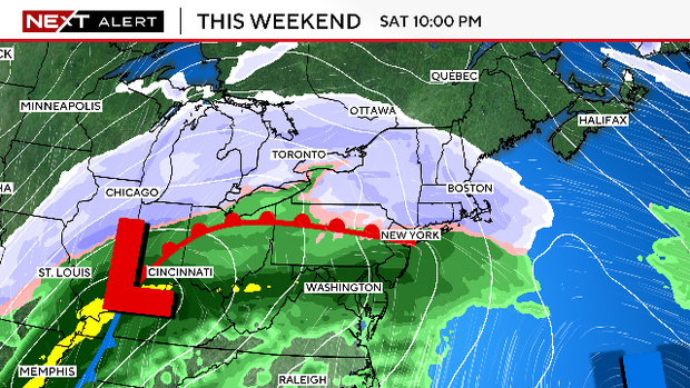
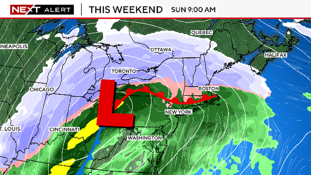
Snow forecast for the weekend
Probably not the news you wanted to hear...it looks like we have another stormy weekend on the way. Unlike our last several storms, this one will be loaded with moisture and also will be slow-moving.
We will be getting much more model data in the next 24 hours. We anticipate that by Thursday afternoon, we will be able to give a reasonable estimate of timing, impacts and snowfall amounts.
In general, we expect this storm to start as snow, sometime around late Saturday afternoon or Saturday evening. We don't expect this to be a major snowstorm, but a plowable snow is a good bet.
We also think it will change to ice and/or rain at some point Saturday night into Sunday morning. The rain/ice will likely linger for a good portion of the day Sunday. So, if you want to get out and about this weekend, the first half of Saturday would be your best bet to stay dry.
We will have much more on this storm in the next 24-48 hours.