Slow-moving band of heavy rain could cause flooding in Massachusetts Thursday; warm weekend ahead
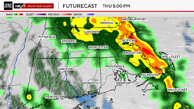
Periods of heavy rain are expected throughout the day on Thursday in southern New England. While it will not be raining at all times and all places, this looks like a situation where, when it is raining, it is pouring.
The heaviest rain across eastern MA will occur between 2 p.m. and 10 p.m. on Thursday. After that, the majority of the downpours will rotate north of our area.
During this timeframe, there could be some localized flooding and ponding on roadways. It will be a slow and wet evening commute.
By Friday, the center of the storm system will move offshore, and most of southern New England will remain within its cyclonic flow.
It will be a very gray day with some pockets of drizzle and showers rotating from north to south on a chilly north-northeast wind.
Localized flooding possible
We may see some clearing very late in the day, around sunset.
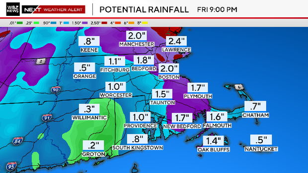
Rainfall amounts will vary widely from town to town. The majority of the area will likely receive between .5"-1.0", but some isolated pockets of 1-2" are possible under the heaviest downpours.
Should rainfall totals exceed 1.0", some localized flooding is possible.
Warmest weekend since October
Following Friday, we are in for a shift of seasons. Temperatures will soar into the 70s and 80s starting on Saturday and lasting through the middle of next week.
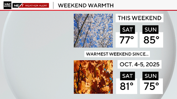
In fact, this weekend will be the warmest weekend in the Boston area since early October.


