Blizzard warning for Boston. Weather forecast maps show where 2 feet of snow could fall in Massachusetts during nor'easter
A major nor'easter could bring blizzard conditions to the Boston area Monday, the latest weather forecast shows.
You can watch WBZ-TV's live coverage throughout the snowstorm on CBS News Boston.
For the first time in four years, the National Weather Service has issued a Blizzard Warning for parts of Massachusetts and southern New England.
Specifically, the warning is for the entire North and South Shores, Boston, Norfolk County, Plymouth County, Bristol County, Cape Cod, and Martha's Vineyard. In addition, blizzard warnings now extend all the way west through Worcester County, Springfield and Hartford, Connecticut.
It is VERY unusual to see blizzard conditions that far inland. Most times, the whiteout is limited to the immediate coastline where winds are strongest and unabated.
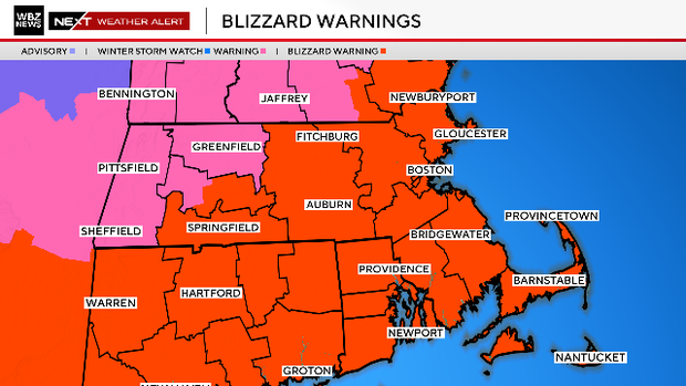
To the west and north of those areas, there is a Winter Storm Warning in place.
What is a blizzard?
In order to achieve blizzard status, the following must occur.
"Considerable falling and/or blowing snow which reduces visibility to less than ¼ mile for 3+ hours AND sustained winds or frequent gusts 35 mph or greater in that same timeframe."
Essentially, whiteout conditions.
This will be an incredibly deep and powerful area of low pressure.
As the storm travels north-northeasterly, it's undergoing "bombogenesis," a fancy term for a very rapidly deepening and strengthening low-pressure system. The central pressure is expected to drop about 33 millibars in just 24 hours, easily achieving bomb cyclone status.
When will the snow end?
We expect bands of snow that will produce snowfall rates of 1-to-3 inches per hour Monday morning into the afternoon.
This will be the absolute brunt and peak of the storm. Blizzard conditions may occur anytime within this window.
During Monday afternoon, the winds will shift to a more northerly direction as the center of the storm starts to pull away from our area. The snow will now pivot from north to south in bands across our area, but also become a bit lighter and more spotty, especially by 5 p.m.
Between 5 and 10 p.m., the bands will pull eastward and eventually move completely offshore.
We don't expect much, if any, accumulation after 10 p.m. Monday.
The worst travel will be through 3 p.m. on Monday. The hours on either side of that will still be tough going, but not quite as severe.
How much snow?
If the current forecast verifies, this could easily be a top ten all-time snowstorm for Boston, the second of this winter!
16-to-24 inches: A wide jackpot zone from the Cape Ann area down through Boston, back to Worcester and covering all of Bristol and Plymouth counties.
10-to-16 inches: Northern Essex, northern Middlesex and northern Worcester counties. Also Cape Cod and Martha's Vineyard. Also the mid to outer Cape and Martha's Vineyard.
6-to-10 inches: Nantucket, southern New Hampshire and most of western Massachusetts.
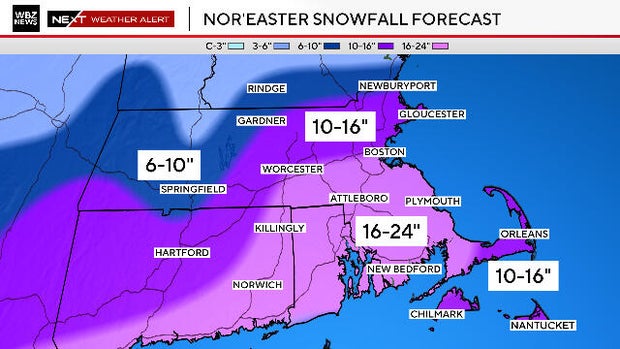
We expect the majority of the snow accumulation to occur Monday morning through early afternoon. Snowfall will continue to accumulate after that, but at a much slower rate.
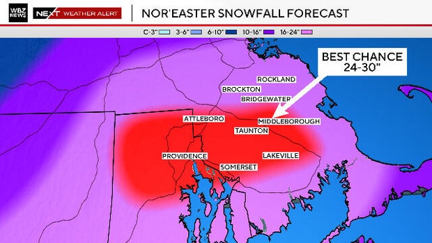
Where is the "jackpot zone?"
The best chance of seeing more than two feet of snow appears to be across inland portions of Plymouth and Bristol counties as well as northern Rhode Island.
This is our best guess for a "jackpot zone".
So if you live in towns like Brockton, Bridgewater, Attleboro or Taunton, you just may be the "winners" this go around.
Will the snow be light and fluffy?
Inland and west of Interstate 95 the snow will mostly be light and fluffy. Not quite as fluffy as the January storm, but still fairly easy to move around.
The snow will be heavier and wetter along the immediate coastline and over southeastern Massachusetts.
By Monday afternoon, the final several inches will be lighter and fluffier.
Wind concerns
Wind is a real concern. Northeast gusts will reach 55-to-70 miles per hour or higher across southeastern Massachusetts, Cape Cod and the Islands.
Just inland from there, we could see gusts between 40-to-55 mph.
Again, the farther west you go, the lower the wind impacts.
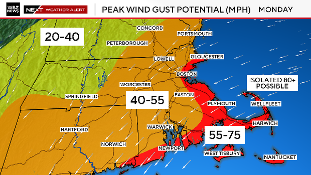
Combine the heavier nature of the snow along the coast with the very strong winds and you get a high likelihood of tree and wire damage as well as power outages.
It is a good idea for all southern New England residents to prepare for the worst this weekend before the storm arrives. Be prepared to lose power and have a plan.
We certainly do NOT recommend driving during the peak of the nor'easter. However, if you must go out, make sure your vehicle is also well-equipped and prepared for a worst-case scenario.
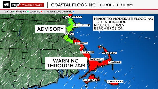
Coastal flooding concerns
Finally, we have concerns about some minor to moderate coastal flooding during the Monday afternoon and Tuesday morning high tides.
There will almost certainly be significant splashover, coastal inundation and beach erosion.
The highest risk of coastal flooding will be in the few hours surrounding each high tide cycle. The times to watch are:
- Monday 2 to 4 a.m.
- Monday 2 to 5 p.m.
- Tuesday 3 to 5 a.m. (north-facing beaches)
Will this storm make history?
Is this bringing back any memories from that insane winter of 2014-2015?
It has been just about as cold, average temperatures have been very similar.
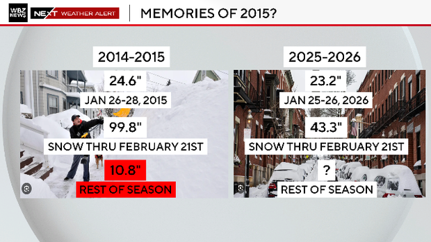
As of this date in 2015, Boston had just about 100 inches of snow, well ahead of where we are FOR NOW. We will see how close we get.
Could we see a run at the history books?
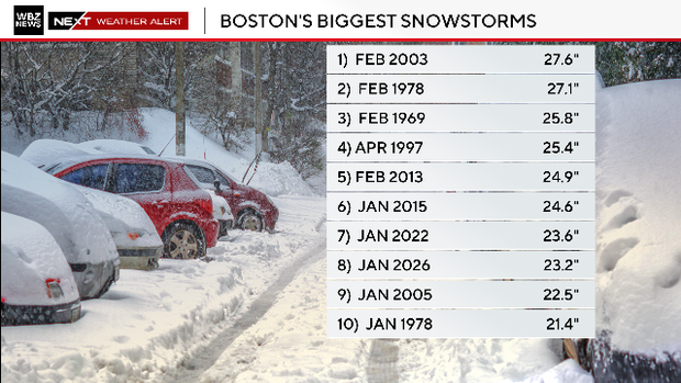
In order to break the top 10 biggest snowstorm list for Boston, this storm would have to drop 21.4" or more, a tall task but NOT impossible!
Stay with the WBZ NEXT Weather Team for frequent updates on WBZ-TV, CBS News Boston and WBZ.com.