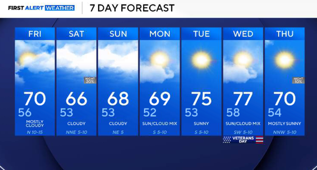
Breezy and sunny conditions expected as slim chance of rain possible for North Texas


A cold front will move through North Texas Thursday evening and night, bringing a wind shift, cooler temperatures and a slight chance of isolated showers.
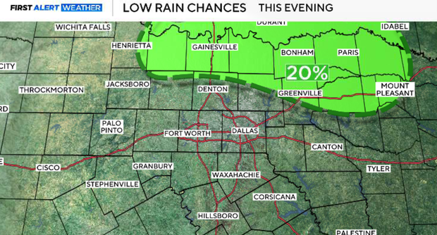
Ahead of the front, southerly winds will increase, helping temperatures climb into the upper 70s and lower 80s. An upper-level disturbance accompanying the front will provide enough lift for a few isolated showers to develop this evening. However, substantial dry air in the middle levels of the atmosphere will limit rainfall coverage.
Rain chances remain low, generally 10–20%, with the best opportunity north of I-20 and east of US-287.
Behind the front, cooler air and breezy northwest winds will arrive Friday.
Increasing cloud cover will also help keep afternoon temperatures closer to seasonal averages. Another upper-level disturbance will move into the region this weekend, bringing more clouds and a slight chance of showers Saturday, especially across our southern and southwestern counties.
Most of North Texas, including much of the DFW metroplex, will remain dry.
The weekend will feel noticeably cooler, with afternoon highs generally in the 60s and chilly mornings in the 40s and lower 50s. Looking ahead, the unsettled pattern will gradually shift east, allowing sunshine to return and temperatures to climb back into the 70s by the middle of next week.
Thursday night cold front
Our next cold front will move southeast across North Texas, bringing a wind shift and a slight chance of showers.
The main window for isolated rainfall will be approximately 5 p.m. to midnight, with the best chances generally north of I-20 and east of US-287, including areas closer to the Red River. Rain chances will remain around 10–20%, and most neighborhoods will stay dry.
Behind the front, winds will shift to the northwest and increase to around 10–15 mph, with some stronger gusts possible. Clouds will linger overnight, limiting how quickly temperatures fall. We're forecasting lows generally in the upper 40s to mid-50s, with DFW around the mid-50s.
Friday: Cooler and breezy
A cooler and breezier day is expected behind Thursday night's cold front.
Northwest to north winds will remain elevated around 10–20 mph, with occasional gusts near 20 mph or slightly higher. Cloud cover will be variable, with partly sunny to mostly cloudy skies throughout the day.
The combination of cooler air, clouds and breezy conditions will keep temperatures closer to seasonal averages, with highs generally in the upper 60s to lower 70s. We're forecasting a high near 70° in DFW.
An isolated light shower cannot be completely ruled out, but the vast majority of North Texas will remain dry. For Friday night football games, temperatures will cool into the 50s, and the north breeze will make a light jacket a good idea.
Mostly cloudy skies will continue as another upper-level disturbance approaches the region. Temperatures will fall into the 40s and lower 50s Friday night, with the coolest readings outside the metroplex.
Winds will gradually decrease, although clouds will remain widespread.
Cool, cloudy weekend
A cooler and cloudier Saturday is expected across North Texas.
Another upper-level disturbance will move through the southern Plains, bringing increasing midlevel moisture and broad atmospheric lift. Although the atmosphere will remain relatively dry across much of our area, enough moisture could develop for isolated light showers, particularly across our southern and southwestern counties.
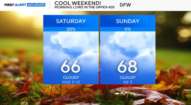
Rain chances will generally remain low across North Texas, around 10–20% in favored locations, with the better opportunity developing during the afternoon and evening. Most of the DFW metroplex and locations farther north should remain dry. Cloud cover and cooler air will keep afternoon temperatures mainly in the 60s, with a forecast high near 66° in DFW.
Cloudy skies will continue Saturday night, with isolated showers possible, mainly across the southern portions of our viewing area. The best rainfall opportunities will remain south of the metroplex, while most of North Texas will experience little or no precipitation. Overnight temperatures will fall into the upper 40s and lower 50s, with some traditionally colder locations reaching the mid-40s.
Sunday, the upper-level disturbance will linger to our southwest, keeping considerable cloud cover across North Texas. Most areas will remain dry, although a stray light shower cannot be completely ruled out in our southern counties. Rain chances will generally remain at or below 10–20% where showers are possible.
Afternoon temperatures will stay slightly below seasonal averages, with highs in the mid-to-upper 60s. We're forecasting a high near 68° in DFW. It will be another comfortable but cool fall day, especially during the morning and evening hours.
Cool and dry start to next week
Monday, the upper-level pattern will begin shifting east, but some cloud cover could linger. Most of North Texas will remain dry, with only a very slight chance of an isolated shower in southern locations. Temperatures will remain near or slightly below seasonal averages, with highs generally in the upper 60s to around 70°. Morning lows will be in the 40s and lower 50s.
Improving conditions are expected as high pressure begins building back into the region on Tuesday. Skies will gradually clear, and southerly winds will return. We're forecasting more sunshine and afternoon highs climbing into the lower to mid-70s. Rain chances will remain very low.
Wednesday, the warming trend should continue as upper-level ridging strengthens and the unsettled weather pattern shifts farther east. With more sunshine and southerly winds, temperatures could climb into the mid-to-upper 70s, once again running above seasonal averages. Dry conditions are expected across most of North Texas.