North Texas to stay noticeably cooler this week with temperatures in 70s


We're enjoying a stretch of pleasant fall weather across North Texas, with cool mornings, comfortable afternoons and very limited rainfall.
The upper-level pattern will become a little more active over the next several days as a couple of disturbances move across the region. However, a substantial layer of dry air in the middle levels of the atmosphere will limit rainfall development.
Quiet weather continues Wednesday night with mostly clear skies and light winds gradually becoming southerly. Temperatures will fall into the upper 40s and lower 50s outside the metroplex, with mid-50s closer to DFW.
Cold front arrives in North Texas Thursday
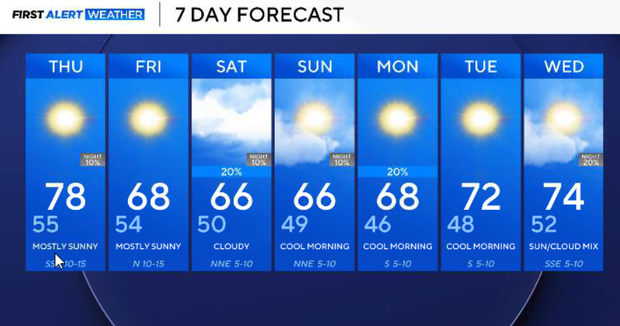
A brief warm-up is expected ahead of our next cold front. Southerly winds will return, allowing afternoon temperatures to climb into the mid-to-upper 70s.
We're forecasting a high near 78° in DFW. We'll begin the day with sunshine, followed by increasing clouds during the afternoon and evening as the next upper-level disturbance approaches.
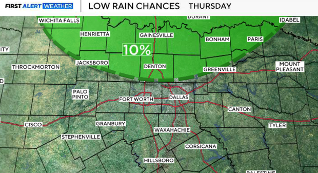
A few isolated light showers will be possible near the Red River Thursday evening, with rain chances around 10%. Most OF North Texas will remain dry.
The cold front will move southeast across the region Thursday evening and Thursday night, bringing breezy northwest winds of 10–20 mph.
Cooler and drier air settles into North Texas behind Thursday night's front. Temperatures will fall back toward seasonal averages, with highs generally in the 60s and cool morning lows in the 40s. Cloud cover will vary, but widespread precipitation is not expected.
Light showers possible this weekend
Another upper-level disturbance will bring increasing mid- and high-level clouds across North Texas on Saturday.
The combination of cloud cover and cooler air behind Thursday's front will keep afternoon temperatures mainly in the 60s. As moisture gradually increases, isolated light showers will become possible throughout the day and into Saturday evening.
Rain chances remain low, generally 10–20%, with the greatest potential south of I-20. This is not expected to be a significant rainfall event, and many locations will remain dry.
Sunday, the unsettled upper-level pattern will begin shifting east, although clouds may linger at times. We're forecasting another seasonably cool day, with highs generally in the 60s to around 70° and cool morning temperatures in the 40s. Rain chances remain limited, with improving conditions expected as the upper-level disturbance moves away.
Early next week, the upper-level ridging is expected to build back into the Southern Plains as the more unsettled pattern shifts toward the East Coast. Skies should gradually clear, and southerly winds will return, allowing temperatures to moderate. We're forecasting highs returning to the lower and mid-70s, with overnight lows generally in the 50s. For now, no significant rainfall is indicated early next week.