Damaging winds, hail, isolated tornadoes possible in North Texas to begin workweek


A line of strong-to-severe thunderstorms will move across North Texas Monday evening and overnight.
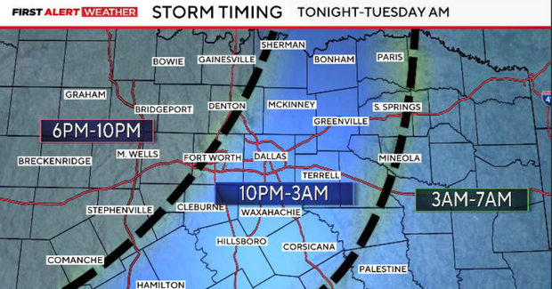
Damaging wind gusts are the primary threat, with a tornado or two also possible. Large hail will be an additional concern with any storms that remain isolated ahead of the main line, across western North Texas early this evening. Our latest forecast places the line of storms across the DFW metroplex between approximately 11 p.m. and 3 a.m., followed by areas farther south and east overnight.
A strong upper-level trough moving east across the Rockies is helping deepen low pressure across the Central Plains, while an approaching dryline and cold front provide the focus for thunderstorm development. Strong southwesterly winds aloft are producing effective wind shear of 45–50 knots, sufficient to support organized thunderstorms.
Increasing Gulf moisture and instability across portions of Northwest Texas are creating an environment favorable for strong to severe storms.
Large hail, damaging winds, tornadoes possible
Storms are already developing across central Oklahoma, and additional activity could extend south toward our northwestern counties. However, the more likely scenario is for storms to develop in the Rolling Plains and approach western North Texas between approximately 4 and 6 p.m.
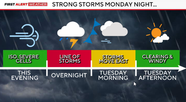
Initially, storms may remain somewhat isolated or semi-discrete, allowing a few supercells capable of large hail, damaging winds and tornadoes. As storms increase in coverage, they are expected to organize into a broken line moving east across North Texas.
Once the line develops, damaging winds become the primary concern. Brief tornadoes may also develop along the northern ends of bowing segments within the line.
Storm chances increase Monday evening
Storm chances will increase across our western counties during the late afternoon and evening. Any storms that remain isolated could develop into supercells capable of large hail, damaging wind gusts and tornadoes. As storms increase in coverage, they should begin organizing into a broken line and moving east toward the metroplex.
The main line of thunderstorms is expected to move through the DFW metroplex between approximately 10 p.m.and 1 a.m. Damaging wind gusts will be the primary severe weather threat, although brief spin-up tornadoes remain possible within portions of the line. Frequent lightning and periods of heavy rainfall are also expected with stronger storms.
Because much of this activity will occur late at night, viewers should have multiple reliable ways to receive severe weather warnings while sleeping.
Storms continue early Tuesday
Storms will continue progressing east and southeast overnight, with the activity expected to exit our eastern counties and the Brazos Valley by midmorning.
Most of the DFW metroplex should be behind the main line before the Tuesday morning commute, although some rain and storms may still affect eastern and southeastern portions of our viewing area early in the morning. A cold front will follow several hours behind the storms, bringing a shift to west-northwest winds.
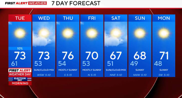
Conditions will improve quickly behind the cold front. Skies will clear from west to east, humidity will decrease, and afternoon temperatures will be noticeably cooler, with highs in the lower to middle 70s. Northwest winds will remain breezy through much of the afternoon, with occasional gusts near 25 mph.
Sunshine returns mid-week
High pressure builds into the Southern Plains, bringing abundant sunshine, low humidity and lighter winds. Morning lows will fall into the 40s and lower 50s, with afternoon highs in the lower to middle 70s.
Thursday, dry and pleasant fall weather continues, with cool morning temperatures and highs generally in the 70s. Another disturbance will approach the Plains late Thursday into Friday, but the better moisture and forcing are expected to remain north of North Texas.
Friday, a reinforcing push of cooler air will keep temperatures slightly below normal. Highs are expected in the upper 60s to lower 70s, with dry conditions continuing.
Forecast confidence decreases somewhat as models differ on the evolution of another upper-level trough approaching the Southern Plains this weekend.
For now, we're favoring mostly dry conditions with near-seasonal temperatures. We'll continue monitoring whether the approaching disturbance brings any meaningful changes to our weekend forecast.