Scattered storms return to North Texas this weekend

Following a warm and dry day for most of North Texas on Friday, unsettled weather returns going into the weekend.
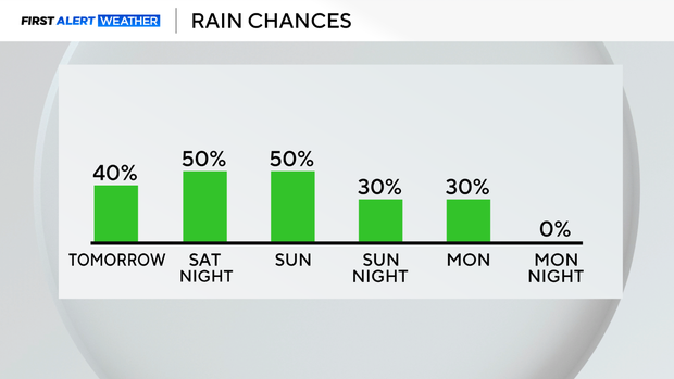
Expect Saturday to start dry, with a gradual increase in cloud coverage as a frontal boundary stalls across the Texas Panhandle and into portions of Oklahoma.
Storms develop Saturday afternoon
This area will be the focus of storm development starting Saturday afternoon, as scattered storms look to start popping first in our northwestern counties.
While the weekend does not look like a washout, in the areas where those scattered storms do set up, they will have the capability to drop heavy rain over a short period of time.
Localized flooding a concern
The greatest concern with these storms will be threats for localized flooding. We have a lack of upper-level shear in the atmosphere, which means the storms will likely be very slow-moving, leading to downpours that continue over one area, as opposed to traveling through quickly.
Sunday brings more storm chances
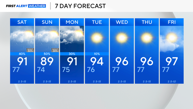
Going into Sunday, expect isolated shower activity during the morning, followed by an increase in shower and storm activity by the afternoon as a result of daytime heating.
Stay weather-aware and alert
Keep an eye on the forecast and the radar throughout the weekend. Remember to never drive into flooded roadways, and if you come under a flash flood warning, that means flooding is imminent, so be mindful of rising water, especially in low-lying areas and near rivers, creeks, and streams.
Be sure you always have multiple ways to receive weather alerts, just in case.
Clearing out next week
Showers look to clear up into the start of next week, and temperatures return to normal numbers, back into the middle 90s by midweek.