After Morning Hail, Evening Storms Expected To Bring Near Hurricane-Force Winds To DFW
NORTH TEXAS (CBSDFW.COM) — Some parts of North Texas were awakened by heavy rain and hail -- from pea-sized to near golf ball-sized -- on Tuesday morning.
The small complex of storms, ahead of a dry line in West Texas, held together enough to impact North Texas early. The radar showed a single storm that strengthened enough to produce hail. The storm activity expanded slightly into a non-severe cluster of storms, moving through places like Navarro, Henderson, and Anderson counties by mid-morning.
But as the morning weather system passes through, the focus turns to the late evening and overnight hours. That is when a cold front, dropping in from the northwest, will push into North Texas and bring severe weather.
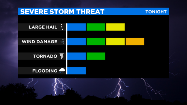
Ahead of the front, much of Oklahoma and North Texas will be under the gun for strong to severe thunderstorms capable of producing damaging winds, large hail, and possibly a brief spin-up tornado.
As it stands, there is a 70% chance for storms -- expected between 8 p.m. Tuesday and 1 a.m. Wednesday and most of North Texas is in the "enhanced risk" category during those hours, which means numerous, damaging severe storms are likely.
The main concern is the possibility for damaging wind gusts of up to 70 mph -- Category 1 hurricane force winds are between 74 and 95 mph.
As the cold front clears the region Wednesday morning, all rain will come to an end with sunshine and cooler weather -- in the 70s -- are in store for the afternoon.


