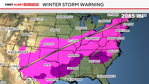
How much rain, sleet and snow will North Texas get this weekend—and when?
North Texas is in for a messy, multi-day winter system with rain, sleet, ice, snow—and then bitter cold.
Saturday
Much of the area will see sleet, with pockets of freezing rain still possible. Roads could become slick, especially north of Highway 380.
Freezing rain/sleet started up in the early morning hours. We are expecting 1" to 2" of sleet in several rounds through the course of the day. A thin layer of ice is expected to be in place under this sleet.
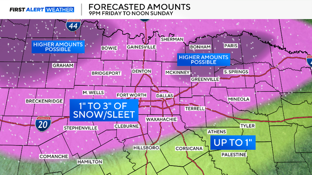
Saturday sleet accumulations, according to the National Weather Service:
- Collin County: 0.5"
- Dallas County: 0.5"
- Fannin County: 1"
- Grayson County: 3.5"
- Tarrant County: 0.4"
How to prevent home heating problems during a winter storm and avoid costly repairs, according to an HVAC expert
Late Saturday into Sunday
It will continue to fall through Saturday night and overnight into Sunday morning as it mixes with snow. It will end with all snow on Sunday morning. Total accumulation of around 2" is possible in spots across the four-county area of metroplex, especially the north.
Sunday 7 a.m.: 1 to 2 inches of snow on top of ice and sleet.
Totals
- Sleet & snow: 1 to 5 inches (most of it sleet)
- Ice: 0.25 to 0.5 inches, with isolated spots up to 0.75 inches
- Highest amounts likely along and north of Highway 380
How Texans can get emergency help during the winter storm, from road conditions to roadside assistance
What comes after
Once precipitation ends, dangerously cold air takes over. Wind chills could drop to 10 below zero Sunday and Monday mornings. Temperatures may stay at or below freezing for more than 72 hours, with some spots not rising above freezing until Tuesday—meaning any leftover moisture could refreeze overnight.
Now's the time to plan ahead: protect pipes, drip faucets, bring pets inside, and avoid travel if possible.