Cold front brings gusty winds, cooler temperatures and elevated fire danger to North Texas
A low-pressure system in Central Texas has brought an increase in cloud cover over North Texas on Tuesday. However, the sun was able to break through the clouds in the afternoon, allowing temperatures to climb into the mid-60s, well above average.
Tuesday night will be mild. Once the sun sets at 5:42 p.m., temperatures will quickly fall into the 50s.
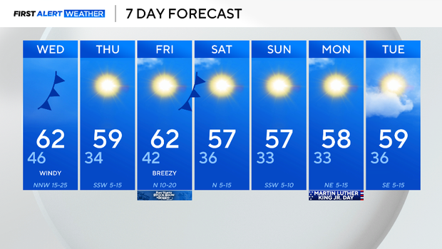
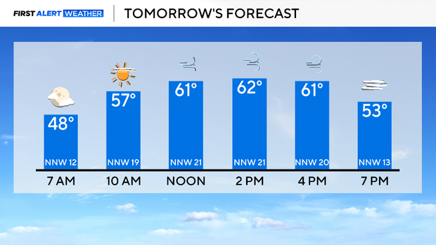
Wednesday will be cool and windy due to a cold front that will pass through the area. Expect winds peaking around 35 mph in the afternoon.
Due to the gusty winds, low relative humidity levels, and dry fuels, fire danger will be elevated along and to the west of I-35. Please avoid any activities that may cause a spark or a flame.
The cooler air mass will settle into the area, resulting in a cold start on Thursday morning. The low will be in the 30s, but a slight breeze will make it feel even colder. Be sure to bundle up.
On Friday, another cold front is expected. This front will bring a slight cool down and gusty winds up to 25 mph. Models have gotten into better agreement with this front; conditions are now looking to stay dry for the first day of the Fort Worth Rodeo & Stock Show.
In addition, this weekend will be seasonal and sunny.
For Martin Luther King Jr. Day, North Texas will be closer to the 60° mark, and the days will stay dry well into next week.