Foggy, wet Monday for North Texas before sunshine returns, temperatures rise

Monday morning is starting out wet in North Texas, after a soggy Sunday dropping more than 3 inches of rain in many areas.
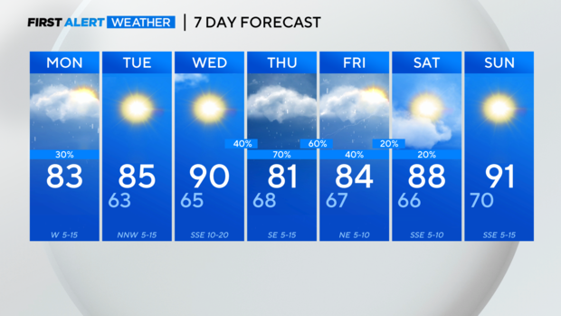
A flood watch is in place until 7 p.m. today for the southeast side of North Texas. While we won't see widespread rain, any shower or isolated storm could lead to flash flooding since the ground is saturated.

A cold front moves through North Texas later today and with it, there is a small chance of some isolated strong to severe storms, mainly on the southeast side of the region. Large hail and damaging winds are possible with these storms at a 20%-30% coverage.

The cold front will sweep out the moisture, leading to a sunny Tuesday and Wednesday.
Late Wednesday, the next upper-level energy arrives, bringing the return of rain and storms in the forecast. As of now, the Storm Prediction Center doesn't have North Texas at risk, but that could change as the week progresses.
Temperatures warm up to the 80s on Monday after topping out in the 60s on Sunday. By Wednesday, the high will be about 90 degrees.
With the next front on Wednesday to Thursday we see a drop in high temperatures to the low 80s Thursday afternoon. However, keep the short sleeves handy because high temperatures warm back to the low 90s by Sunday.