Fire danger sticks around North Texas with gusty winds and low humidity
Tuesday was a cooler day in North Texas, although still above average, following the passage of a dry cold front in the morning.
As a result, very dry air and breezy conditions have settled in briefly for the midweek, but we do have some late-week changes on the way.
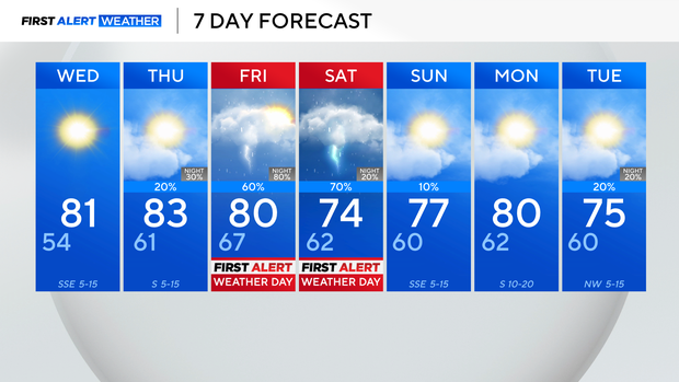
For Wednesday, expect a cool start, with lows in the mid-50s. Highs then return to the lower 80s during the afternoon, with lots of sunshine, and just a slight breeze.
By Thursday, clouds start to build as a warm front lifts through the region. This will usher in just isolated shower chances during the afternoon and evening.
This is all ahead of a stronger cold front and an area of low pressure arriving Friday into Saturday.
We have issued First Alert Weather Days for both Friday and Saturday for the risk of strong thunderstorms and heavy rains.
Those showers look to clear west to east throughout the day Saturday, with drier and cooler air filtering in on Sunday.