North Texas flooding threat continues through Friday


Another disturbance will approach Thursday night, followed by a southwest-to-northeast-oriented cold front on Friday. This will allow additional showers and thunderstorms to redevelop overnight and continue at times Friday.
The biggest concern with any additional heavy rain is that many locations are saturated after this morning's rainfall. It will take less additional rain to produce runoff and renewed flooding in vulnerable locations.
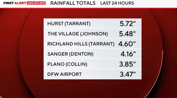
How much rain has fallen in Dallas, Fort Worth?
The morning round produced 1–3 inches of rain across much of the area, with numerous pockets of 4–5 inches. We will continue updating these numbers as additional observations come in.
Rain coverage should continue decreasing through the evening as Thursday's main area of convection moves east. Most locations should get a relative break for at least part of the evening, although lingering showers and an isolated thunderstorm remain possible.
Rain chances increase again later Thursday night as another disturbance approaches. There is a 70–80% chance for redevelopment, with the greatest coverage expected along and east of I-35 and south of I-20. There is more uncertainty regarding how widespread the rain becomes north of I-20, but scattered showers and thunderstorms will still be possible toward Friday morning.
Cold front hits North Texas Friday
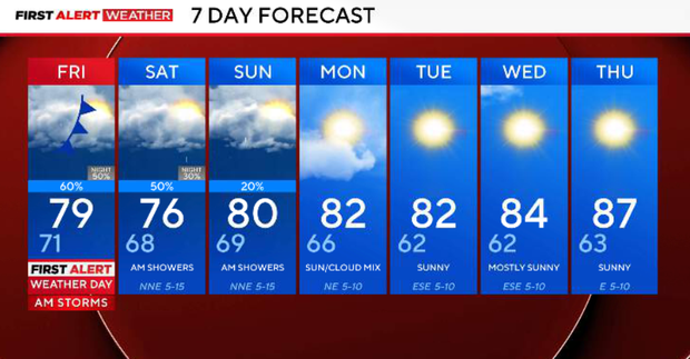
The cold front finally pushes slowly through North Texas early on Friday. Lift associated with both the front and the upper-level disturbance will keep scattered showers and thunderstorms in the forecast through the day. This does not currently look like a repeat of Thursday morning's widespread heavy-rain event. However, additional rain falling on already wet areas means localized flooding will still need to be monitored.
Expect another cloudy, damp and cool day, with much of North Texas remaining in the 70s. Behind the front, the atmosphere becomes increasingly stable, so showers should become more dominant than thunderstorms.
North Texas may see scattered showers this weekend
The upper disturbance will be weakening, but enough moisture and lift remain for scattered showers. Coverage should be lower than Friday, but the latest guidance still supports roughly 50% coverage Friday night into Saturday. Temperatures remain below normal, generally in the 70s.
Rain chances continue to decrease, but we're not completely finished yet. Scattered showers remain possible, with 20–30% coverage. North Texas should gradually begin transitioning toward the much quieter pattern that arrives next week.
A second weak cold front arrives from the northeast around Monday as high pressure builds over the Southern Plains. That finally shuts down the prolonged wet pattern.
Monday through much of next week looks mostly clear and considerably drier, with afternoon highs generally in the 80s and comfortable mornings in the 50s to lower 60s.