Temperatures climb into 80s as rain chances remain slim across North Texas


Another beautiful fall day is underway across North Texas.
After a refreshing start with temperatures in the upper 40s and 50s, we'll warm into the upper 70s and lower 80s Tuesday afternoon. High pressure and upper-level ridging remain firmly in control of our weather, keeping skies mostly sunny, winds light and humidity relatively low.
Temperatures will continue climbing gradually through the week, with afternoon highs returning to the middle 80s by Thursday and Friday. Although that's above normal for late October, we're not expecting extreme heat or temperatures approaching record levels.
Unfortunately, our dry weather pattern also continues. Storm systems moving across the country are being diverted around the ridge, keeping meaningful rainfall away from North Texas. A potential change in the upper-level pattern next week could eventually allow a cold front and some rain chances to return, but confidence remains low regarding timing and impacts.
Tuesday, a pleasant evening is expected, with mainly clear skies and occasional passing high clouds. Winds will become light and variable overnight, allowing temperatures to cool efficiently after sunset. Most communities will fall into the lower and middle 50s, with a few outlying locations potentially dropping into the upper 40s.
We can expect a low near 57° at DFW. A very weak upper-level disturbance will pass north of Texas overnight into Wednesday. It may bring some additional high clouds, but no rainfall is expected.
Another beautiful day is expected on Wednesday as upper-level ridging continues across the Southern Plains.
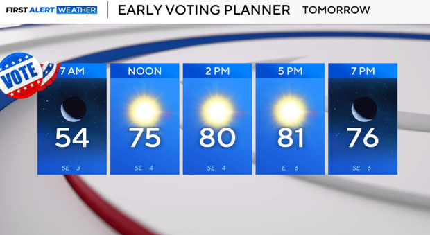
We'll start with temperatures generally in the 50s, followed by another pleasant afternoon with sunshine and passing high clouds. East-southeast winds will remain light, helping keep the warming trend gradual. Afternoon highs will range from the upper 70s to the lower and middle 80s across North Texas.
Humidity should remain relatively comfortable, and no rain is expected.
Warming trend continues in North Texas on Thursday
The warming trend continues as the upper-level ridge remains the dominant weather feature. Morning temperatures will generally be in the middle 50s to lower 60s, followed by afternoon highs in the lower and middle 80s.
The high will be around 84–85° in Dallas–Fort Worth, with some locations potentially reaching the upper 80s.
Skies will remain mostly sunny with occasional high clouds. Despite the warmer temperatures, moisture levels will remain relatively limited, so conditions should not feel excessively humid. No rain is expected.
Friday, another warm, mainly sunny and dry day is expected.
Afternoon temperatures will once again reach the lower and middle 80s, with a high near 85° at DFW. An upper-level trough will continue developing over the western United States, sending several weak disturbances into the Plains. However, these disturbances will remain displaced north and west of North Texas, while the ridge continues protecting our region from significant rainfall. A few more clouds may begin appearing, but the overall forecast remains dry.
Beautiful, sunny weekend in DFW
The weekend begins with another pleasant morning, followed by a warm afternoon. Temperatures will generally start in the upper 50s and lower 60s before climbing into the lower and middle 80s. Highs around 84–85° in the metroplex.
Sunshine will continue, although some passing high clouds are possible as the upper-level pattern begins slowly evolving.
Winds should remain light to moderate, and humidity is not expected to become excessively high.
Sunday, the upper-level ridge will begin weakening and gradually shifting eastward, allowing additional cloud cover to spread into parts of North Texas.
Morning temperatures will remain comfortable, generally in the upper 50s and lower 60s.Afternoon highs should reach the lower and middle 80s, although additional clouds could hold temperatures a degree or two lower than Saturday.
A developing upper-level trough over the western United States may begin shifting east, with moisture increasing across West Texas. However, any meaningful rain chances are expected to remain outside North Texas through the weekend. The Metroplex forecast remains dry.
Pattern change could be ahead
The pattern may begin changing as the upper-level ridge flattens and shifts toward the Gulf states. This could allow a more progressive weather pattern to develop across the Southern Plains. For now, Monday still looks mainly dry across Dallas–Fort Worth, with a few more clouds and afternoon temperatures generally in the lower to middle 80s.
Some longer-range model guidance suggests that a frontal boundary and upper-level disturbance could approach North Texas sometime next week.
If the ridge weakens sufficiently, this could eventually open the door to returning rain chances. However, the timing, coverage and potential rainfall amounts remain highly uncertain. There is currently no strong indication of a significant intrusion of cold air, so temperatures may remain above normal even if a front eventually arrives.
We'll continue monitoring the pattern, especially given the ongoing need for rainfall across North Texas.


