Expect a beautiful fall week across North Texas with cool mornings, temperatures in the 70s and 80s


A beautiful stretch of weather continues across North Texas as high pressure remains our dominant weather feature.
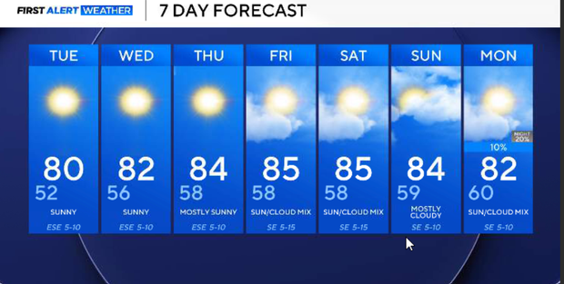
A gradual warming trend this week will take us into the mid and upper 80s later this week. Although temperatures will climb above normal, humidity levels will remain relatively comfortable, particularly during the first half of the week. Our forecast remains dry through most of the week. A weak cold front may approach the Plains on Friday, but it is unlikely to reach North Texas.
Temperatures started in the 40s across many communities outside the metroplex Monday morning, including readings near 42° around Lake Ray Roberts.
Beautiful stretch of weather continues across North Texas
The metroplex remained a little warmer, with temperatures generally in the lower and middle 50s. With sunshine and occasional passing high clouds, temperatures will climb into the middle and upper 70s this afternoon.
We are forecasting a high of 77° at DFW, right around our average high for this time of year. Winds will remain light from the east and southeast at approximately 6–12 mph. Dew points will stay in the 40s, keeping humidity low and conditions very comfortable. It's an excellent afternoon for outdoor activities or lunch on the patio. High clouds will continue streaming into North Texas from the Pacific, but the air beneath them remains exceptionally dry.
A pleasant evening is expected with partly cloudy to mostly clear skies and light southeast winds. Temperatures will fall quickly after sunset as dry air allows heat to escape. Overnight lows will generally range from the upper 40s in outlying areas to the lower and middle 50s across the metroplex. You can expect a low near 52° at DFW. No rainfall is expected.
Tuesday will bring another beautiful day, with a slightly warmer afternoon. Morning temperatures will remain comfortable, generally in the upper 40s and 50s, followed by a gradual warm-up under mostly sunny to partly cloudy skies.
High pressure over the eastern United States will continue influencing our weather, keeping winds light from the east and southeast. Afternoon temperatures will climb into the upper 70s and lower 80s, with a forecast high near 80° in DFW. Humidity should remain relatively low, making the afternoon feel comfortable despite the warming temperatures.
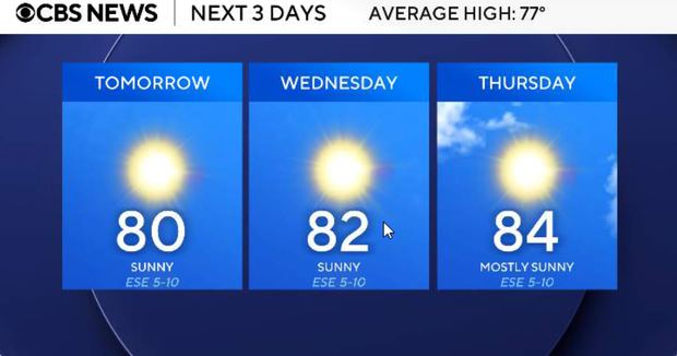
Wednesday, the warming trend becomes more noticeable as upper-level ridging strengthens over the Plains. Morning temperatures will generally be in the 50s and lower 60s, followed by afternoon highs in the middle 80s. We are expecting highs around 84–86° in the Metroplex, several degrees above normal. Sunshine will remain plentiful, although occasional high clouds may pass overhead. Humidity will increase slightly as southerly flow develops, but conditions should remain reasonably comfortable. No rain is expected.
Thursday, high pressure and upper-level ridging will continue to dominate our weather. Morning lows will generally be in the upper 50s and lower 60s, followed by afternoon highs in the middle and upper 80s. A few locations could approach the upper 80s, particularly where sunshine is uninterrupted. Southerly winds may become a little more noticeable, allowing modest moisture return, but significant humidity and rainfall are not expected.
Another warm and mainly dry day is expected Friday, with afternoon temperatures reaching the middle and upper 80s. An upper-level disturbance moving out of the western United States will help push a weak frontal boundary southward into the Plains. However, the upper-level support is expected to move away quickly, and the front will likely stall or weaken before reaching North Texas. As a result, no meaningful cooldown is currently anticipated. Rain chances will remain very low across the region.
Warm and dry this weekend
Warm and mainly dry weather is expected to continue into the weekend. Morning temperatures should generally be in the upper 50s and lower 60s, followed by afternoon highs in the middle and upper 80s. Some additional cloud cover may develop as the upper-level ridge begins to weaken.
Even with the warmer afternoons, mornings should remain relatively comfortable. No significant rain chances are currently expected.
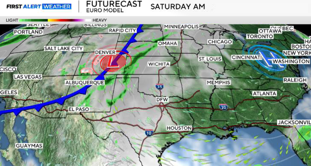
Sunday should remain warm, with highs generally in the middle 80s and possibly upper 80s in some locations.
The upper-level ridge will begin breaking down, allowing the possibility of a few showers or thunderstorms to approach our northwestern counties later in the day. At this point, rain chances remain very low and are mainly confined to areas northwest of the Metroplex.
Most of North Texas, including Dallas–Fort Worth, is expected to remain dry. We'll continue monitoring whether any meaningful rain chances develop heading into the following week.