Cool, damp and gloomy to start weekend for North Texas as rain continues throughout Friday

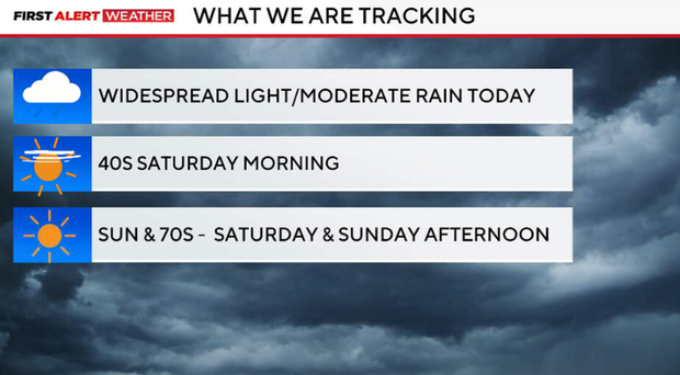
Friday looks cool, damp and gloomy. Most of North Texas will see steady light to moderate rain, while the heavier, more persistent rain stays south into Central Texas.
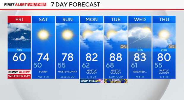
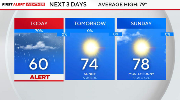
Thunderstorm activity will be limited on Friday, so this is mainly a rain event, not severe weather. It will be a cool day with temperatures staying well below normal, stuck in the upper 50s to near 60.
Rainfall totals will vary:
- North of I-20: generally lighter, around a trace to ½" of rain
- South of I-20: heavier totals of 1" to 2", with isolated higher amounts
Friday evening, rain will gradually taper off from west to east, with lingering light precipitation ending overnight. Clouds will begin to clear late in the night, allowing cooler air to settle in.
Overnight, lows will fall into the upper 40s to low 50s, setting up a crisp start to the weekend.
A look at your weekend
It will be a completely different feeling on Saturday. The day starts cool, with morning temperatures in the 40s to low 50s under clearing skies. Afternoon temperatures will reach the low to mid-70s, with much lower humidity (dewpoints in the 40s), making it feel very comfortable.
Expect plenty of sunshine and dry conditions... a great day to be outside.
Sunday will be another pleasant and quiet day. Southerly flow begins to return, but moisture remains limited, so North Texas stays dry with mostly sunny skies.
Temperatures will be a bit warmer on Sunday, climbing into the mid to upper-70s – comfortable.
The week ahead
Monday will still look tranquil and dry, with a gradual warming trend continuing. Moisture begins to return late in the day, but conditions remain pleasant overall. Highs warm up to the 80s. However, it may be breezy with winds gusting at 10 to 15 mph. Gusts as high as 30 mph may move in, too.
Tuesday and Wednesday will be warmer and more humid, with highs climbing into the 80s and possibly near 90. A cold front approaching the region may bring isolated to scattered showers and storms Tuesday evening into Wednesday, though coverage currently looks limited.