Workweek starts warm and cloudy; threat of hail and damaging winds expected midweek in North Texas
Get out and enjoy the warm start to spring over the next two days. Starting Wednesday afternoon, we'll have a threat of severe weather with rain and storms in our forecast every day that follows through next Monday.
There will be a lunar eclipse on Tuesday morning, so look to the west at a full moon falling into Earth's shadow, turning a reddish glow (the "Blood" moon).
We'll have a breezy day with elevated fire risk in our western counties. We are waiting for some rain, and it's coming in waves. First Alert Weather Days are in place.

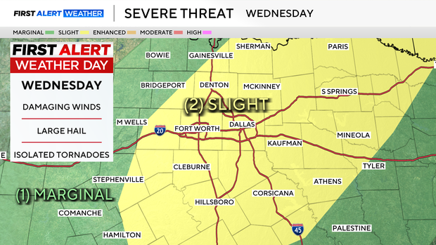
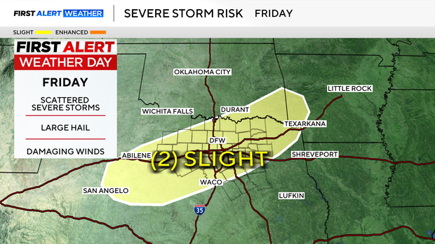
The first chance of severe weather arrives Wednesday afternoon and evening. Large hail and damaging winds are the primary threats. Thursday looks like morning storms and a calmer afternoon. Friday afternoon, the severe threat returns.
There is a good chance that we get a month's worth of rain from Wednesday to Monday. Some forecast models are suggesting as much as 5" of rain in some areas of North Texas. Most of this will fall over the weekend, when the flooding threat will be the highest.
This week will deliver the great "greening" of North Texas. We have enjoyed an early start to spring with all these 80-degree days of late. All that is missing is the rain.
Don't forget that on top of all this weather we are expecting this coming weekend, we "spring forward" the clocks to daylight saving time.