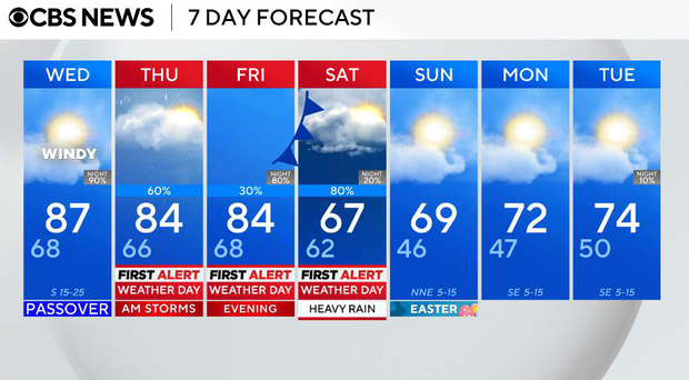
Expect warm temperatures, winds up to 30 mph as round of storms head for North Texas
It has been a warm, humid and windy Tuesday, and that summer-like feel will continue.
So long to the hottest March on record
Did you know that this was the hottest March ever at DFW?
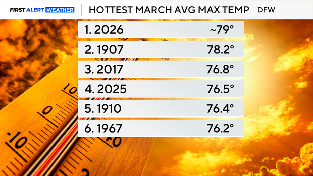
There were 27 days above and only 4 were below average. The average high for this time of year ranges from the middle 60s to the low 70s. In addition, two daily record highs and two daily record warmest lows were broken.
The hottest day was 95 degrees and DFW had two days in the 90s this month, resulting in this March tying for sixth place in the most 90-degree weather days.
Speaking of, DFW received the first 90-degree weather day on March 21, which is 29 days before the average first 90-degree weather day.
This month has broken the record for the hottest average high temperature of about 79 degrees and the monthly average temperature of around 67.6 degrees.
Intermittent storms return to North Texas this week with hail and strong winds
Tuesday evening, a few weakening showers or storms may try to move in from the west (nothing severe expected), with a few possibly reaching our northwest counties, including Montague, Jack, and Wise. The metroplex should remain dry.
Wednesday will be warm again, with highs in the mid 80s. Southerly winds will gust between 25 and 35 mph during the afternoon, helping to increase humidity across North Texas.
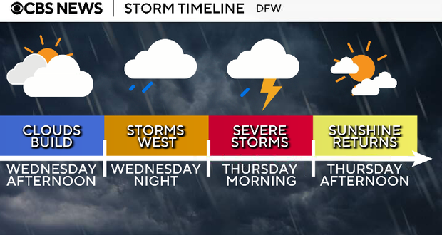
By Wednesday evening, storms are expected to develop west of the region along a dryline and begin organizing into a line as they move east toward the metroplex. That line of storms will move into North Texas during the early morning hours on Thursday, impacting areas near and west of I-35 first, before gradually weakening as it pushes east.
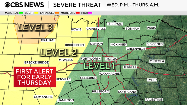
The metroplex is currently under a Level 1 (marginal) risk; however, areas west and northwest of Dallas-Fort Worth are under a Level 2 risk. This includes parts of Parker, Palo Pinto, Wise, Cooke, Jack and Young counties.
While not everyone will see severe weather, a few storms could produce:
- Strong wind gusts
- Up to half-dollar-sized hail
- Heavy rainfall, which could lead to localized flooding
By Thursday morning, storms will be exiting to the east, though some areas may still see lingering rain during the morning commute. Clouds will gradually clear from northwest to southeast on Thursday afternoon, allowing for some sunshine.
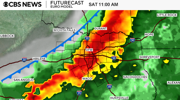
Friday will be mostly cloudy, windy, and warm once again. Our next round of storms arrives Friday evening into Saturday. Some of these storms could again become strong to severe, with an added concern for heavy rain.
Behind that system, a cold front moves through, bringing breezy conditions Saturday and a cooler feel for the weekend. Highs both Saturday and Sunday will be in the upper 60s. By Easter Sunday, sunshine returns with lighter winds and only a very low chance for a leftover shower.