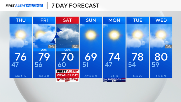
Temperatures to top out in mid-60s Wednesday; rain returns Valentine's Day weekend
Wednesday was a bit cooler across North Texas, following the passage of a cold front Tuesday night, that brought spotty showers to parts of the region.
We were still above average, however, and that will remain the case for temperatures, through much of the extended period.
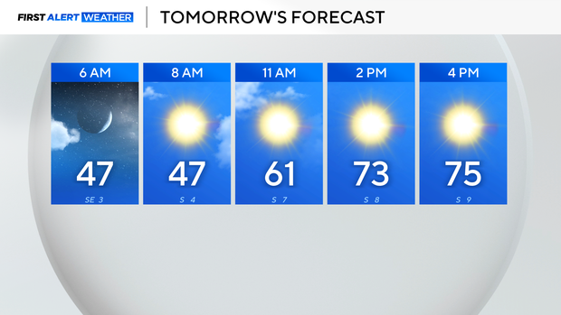
ForThursday, expect a few clouds out, with lows in the mid to upper 40s, and highs warming to the middle 70s.
By Friday, cloud coverage will have increased significantly out ahead of Saturday's system.
Expect dry conditions most of Friday, with just an isolated shower chance mainly along the Red River.
Highs still warm near 80 for the metroplex Friday afternoon, then it's the late-evening and overnight hours that rain starts to roll in.
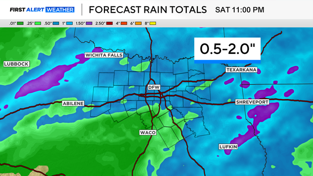
Expect showers to really pick up Saturday morning and continue into the afternoon. We are looking at beneficial rain for just about everybody in North Texas, so keep the rain gear handy, and maybe make indoor plans for the Valentine's Day holiday.
Rain totals look to range from about 0.5" on the lower end, and upwards of 2" on the high end. We could see isolated pockets even higher, in the 2-3" range. Better chances for that will be north of I-20 and east of I-35.

That rain starts to clear up Saturday evening and into early Sunday, then we are looking at a much nicer end to the weekend, with temperatures in the upper 60s on Sunday and sunshine.