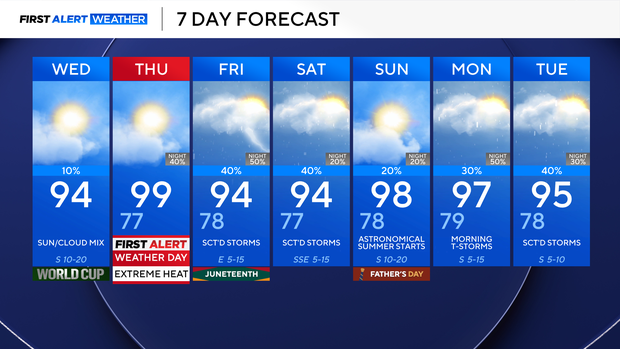
Temperatures spike into upper 90s, prompting heat advisory for North Texas as Tropical Storm Arthur forms off Gulf Coast

Tropical Storm Arthur forms off Texas' Gulf Coast
Tropical Storm Arthur formed on Wednesday off the Gulf Coast of Texas, becoming the first named storm of the Atlantic hurricane season.
After strengthening briefly, the storm is expected to make its way onto land, tracking to the northeast along the coast of Texas into southern Louisiana through Wednesday night, according to the National Hurricane Center. Arthur is then expected to turn inland over Louisiana before weakening.
The National Hurricane Center warned the storm would continue to bring heavy rain and flooding to a vast stretch of the southeastern United States, from Houston to Atlanta. In an advisory, forecasters said the storm was "expected to cause life-threatening flooding" and powerful winds in parts of the region.
First Alert Weather Day for DFW
Looking ahead to Thursday, a First Alert Weather Day is in place due to extreme heat, with a heat advisory in effect at noon. Feels-like temperatures will reach 110°, with actual temperatures approaching 100°.
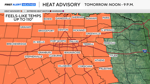
A front approaches on Thursday night, which will increase rain chances, but unfortunately, this won't do too much to the feels-like temperatures.
Expect heat index values or feels-like temperatures to remain at or above 100 ° this weekend and well into next week. Father's Day looks mainly dry with only an isolated shower or storm chance. Stay cool.