After rainy weekend, heat and humidity return to North Texas


Following a weekend of heavy rain, flooding concerns and a record-setting 3.55 inches of rainfall at DFW Airport on Sunday, North Texas is transitioning back to a more typical early summer pattern.
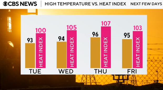
A strong upper-level ridge is rebuilding across Texas, bringing hotter temperatures, lower rain chances, and increasing humidity through much of the workweek. Afternoon heat index values will approach or exceed 100 degrees at times, especially Tuesday through Thursday.
The good news is that many areas will finally get a chance to dry out after several rounds of weekend storms. The next opportunity for rain will arrive late Thursday into Friday as a weak front approaches from the north, beginning to weaken the ridge.
Any isolated showers will fade after sunset on Monday. Warm and muggy conditions continue overnight with lows in the middle to upper 70s.
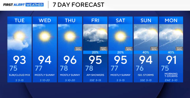
Tuesday, the upper-level ridge becomes centered over Texas, resulting in hotter temperatures and even lower rain chances. Most locations will remain rain-free, with highs climbing into the mid-90s. Heat index values will once again approach 100 degrees.
Hottest stretch arrives Wednesday, Thursday
The hottest stretch of the week arrives as the ridge remains firmly in control. Afternoon highs will reach the mid to upper 90s with heat index values near 100 degrees. Sunshine, humidity, and gusty south winds will make it feel very much like summer across North Texas. Rain chances remain very limited through Thursday.
Friday, a weak front will approach from the north as the ridge begins to weaken. This boundary may help spark thunderstorms across Oklahoma, with some activity potentially moving into North Texas late Thursday night into Friday. While confidence in exact timing remains low, rain chances will begin to increase heading into the end of the workweek.
Scattered weekend showers in North Texas
Scattered showers and thunderstorms may return late Saturday into Sunday as the front settles closer to North Texas and the ridge weakens further.
At this point, coverage appears much lower than what we experienced this past weekend. While a few storms will be possible, the current forecast does not suggest a washout.
Temperatures may ease back a few degrees if clouds and rain become more widespread.
The weather pattern this week will be a sharp contrast from the weekend. Instead of widespread rain and flooding concerns, the focus shifts back to summer heat and humidity. North Texas will spend much of the week under the influence of high pressure, with temperatures climbing into the 90s and heat index values near or above 100 degrees before rain chances slowly return late in the week.