North Texas to see late-day heat advisory Tuesday as heat indices hit triple digits


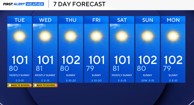
Another hot and increasingly dry week is ahead for North Texas. Highs will remain near 100° through much of the week, while rain chances essentially disappear after today.
The bigger change will be increasing south winds and decreasing afternoon humidity. Combined with an increasingly dry landscape, this will lead to a gradually increasing wildfire threat, particularly across western North Texas later this week.
DFW has now gone 25 consecutive days without measurable rainfall. The last measurable rain at DFW was July 15.
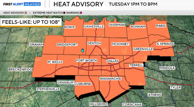
North Texas will be under a heat advisory for the latter half of Tuesday, from 1 p.m. until 8 p.m. Heat index values could reach 108°, increasing the risk of heat-related illness, especially for anyone working or spending extended time outdoors.
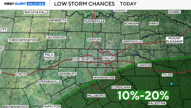
Monday is another hot afternoon with highs around 100°. A weak tropical disturbance moving northwest out of the Gulf will push some moisture north and that may be enough for a few very isolated thunderstorms Monday afternoon and evening. Rain coverage will only be around 10–20%, with the best opportunity south of US-84 and east of I-35. A stray shower or storm could reach as far north as the I-20 corridor. Severe weather is unlikely, although an isolated storm could produce a strong or severe wind gust. South winds will also become breezy at 10–15 mph, occasionally gusting 20–25 mph.
Monday night will be warm, humid, and quiet. Overnight lows will remain in the 70s to lower 80s.
A heat advisory is in effect Tuesday from 1 p.m. to 8 p.m. for much of North Texas, including the DFW metroplex. Heat index values could reach 108°, increasing the risk of heat-related illness, especially for anyone working or spending extended time outdoors. Highs will remain near 100°. South to southwest winds will strengthen, with gusts potentially reaching 25–35 mph.
Hot, dry and breezy conditions continue
The limited tropical moisture starts to exit on Wednesday, and considerably drier air begins moving into North Texas. Highs will again reach the upper 90s to lower 100s with no meaningful rain expected. The combination of gusty south winds, low afternoon humidity and increasingly dry vegetation will begin increasing the wildfire threat.
Thursday is potentially the driest day of the week. Afternoon relative humidity could fall to just 18–25% along and west of US-281, while south/southwest winds remain gusty. With temperatures near 100°, dry vegetation and wind gusts potentially reaching 25–35 mph, fire-weather concerns will be greatest across western North Texas.
Dry heat continues into the weekend
There is little indication of a meaningful pattern change. Slightly above-normal temperatures continue with highs generally in the upper 90s to lower 100s. Rain chances remain very low to nonexistent, allowing already dry conditions to worsen.
How to avoid heat stroke
The Centers for Disease Control and Prevention recommends trying to stay indoors with air-conditioning when possible in the peak summer heat. But if you need to head outside into the sizzling conditions, here's some expert advice:
Dress for the weather: The CDC suggests wearing "lightweight, loose-fitting clothing" in order to stay as cool as possible outdoors.
Take it slow: If you're not used to working or exercising in a hot environment, be sure to pace yourself. "If exertion in the heat makes your heart pound and leaves you gasping for breath, STOP all activity," the CDC's website warns. "Get into a cool area or into the shade, and rest, especially if you become lightheaded, confused, weak, or faint."
Stay hydrated: No matter your activity level, drink plenty of fluids, the CDC says, and don't wait until you're thirsty. Water is a good option, or a sports drink can help replenish salt and minerals lost through sweat. "Stay away from very sugary or alcoholic drinks — these actually cause you to lose more body fluid," the organization adds.
Wear sunscreen: Don't skip sunscreen, since "sunburn affects your body's ability to cool down and can make you dehydrated," the CDC notes. A broad spectrum sunscreen with an SPF of 30 or higher is your best defense against the sun's harmful rays.
What are the symptoms to watch for?
Heat-related illnesses include a spectrum of issues, including sunburn, heat rash, heat cramps, heat stroke and heat exhaustion.
Heat rash is a red, stinging rash that develops when you're hot and sweaty. "It's most likely to show up in areas where sweat gets trapped, like inside your elbows and behind your knees," the Cleveland Clinic notes.
Heat cramps — painful muscle cramps that can strike when you're exercising in hot weather — can develop when you sweat so much that your body loses essential salts and fluids.
Heat exhaustion, which occurs when your body can't cool itself through sweating, can progress to heat stroke if left untreated. Both can cause your body temperature to rise to dangerous levels, dizziness, nausea and fainting or passing out.
Children and the elderly are especially susceptible to heat exhaustion and should be especially careful.
With heat exhaustion, a person's body temperature may top 101 degrees Fahrenheit, along with symptoms like heavy sweating; cold, pale, clammy skin; tiredness or weakness; muscle cramps; dizziness; nausea or vomiting, and more.
If these symptoms arise, "get out of the sun, try to bring your temperature down and seek medical attention if your symptoms continue to get worse," the Cleveland Clinic advises.
What to do if someone has a heat stroke
If it progresses to heat stroke, body temperature can exceed 104 degrees or even higher.
Heat stroke is the most severe heat-related condition — "a medical emergency," according to the CDC. "Call 911 immediately."
When heat stroke occurs, "The body's mechanisms for dealing with heat are overwhelmed," Dr. Thomas Waters, an emergency physician, explains on the Cleveland Clinic's website. "Without treatment, [it] can be deadly."
A person with heat stroke may stop sweating, and can experience dizziness or fainting, headaches, nausea, confusion, or seizures.
Don't rely on temperature alone for self-diagnosis. The CDC points out one way of differentiating the symptoms is that heat exhaustion includes cold, pale and clammy skin while heat stroke involves red, hot, dry or damp skin.
You also treat each situation differently.
For heat stroke, the CDC says to call 911. Move the person to a cooler place, try lowering their temperature with cooler clothes or a cool bath, and don't give the person additional liquid to drink.
For heat exhaustion, moving to a cooler place with cooler clothes can help, in addition to sipping water. If the person begins throwing up, has worsening symptoms or symptoms that last for more than an hour, the CDC recommends getting medical help.


